MID-TERM REPORT SSG 2.194"GPS
WATER LEVEL MEASUREMENTS"
Chairman:
Gerry Mader (USA) Co-chairs:
Doug Martin (USA) & Tilo Schöne (Germany) IntroductionThe
SSG acts as a forum to exchange information about using GPS-buoys
primarily for measuring the instantaneous sea level. Originally the
establishment of the SSG was a request of the community to calibrate
and monitor the satellite radar altimetry (RA) measurements of recent
and forthcoming RA missions. Beside this, members of the group are
using the techniques also for river or lake level monitoring. The
GPS buoy technique is very new and not yet well established. Different
groups are using different types of buoys and concepts. Members from
the US (OSU/Ohio or JPL) and the colleagues from Spain are using
life-saver types of buoys. The concept is very straight forward and
gives good results. Another concept is using ruggedized types of
buoys, which are more suitable for harsh conditions and long-term
deployment. Unfortunately this concept is very expensive. For example,
for the absolute calibration campaign of ENVISAT, the European Space
Agency ESA favorite a dual concept: ruggedized buoys for the long-term
measurements and using life-saver types of buoys in a leapfrog
scenario to get more calibration values, if the weather permits
operations. WEB Server(http://op.gfz-potsdam.de/altimetry/SSG_buoys/index.html) A web
page was established for Special Study Group 2.194 "GPS Water
Level Measurements" on the GFZ web server in Potsdam. In addition
to the Terms of reference for SSG 2.194, the web site provides a list
of the members with contact information, information activities and
news of pending conferences and workshops, an electronic library, and
an opportunity for members to submit a Technical Note on research and
development activities to create a forum for discussing technical
issues related to GPS water level measurements. Unfortunately, this
feature has not been as active as the Chairs had hoped. The electronic
library is widely used but needs updating .
Figure1:
Access Statistics RECENT MEETINGS AND ACTIVITIESA
meeting was held at the EGS in Nice (April 2000). Here, mostly
colleagues from Europe attended the meeting. In total 5 presentations
were given (for the full report,
see the SSG WEB-page: http://op.gfz-potsdam.de/altimetry/SSG_buoys/ssg_meeting_nice.html). 1Tilo
Schöne reported about the planned GPS-buoy activities at GFZ. Within
a larger project, which now founded, a ruggedized buoy will be
deployed in the North Sea. A triple crossover is selected, for which a
crossover of ERS-2/ENVISAT intersects with a GFO and Topex/JASON-1
track. The lifetime of the buoy will be several years in order to
monitor a bias and drift of the respective radar altimeter. The buoy
will be equipped with additional sensors (e.g. wind speed, air
pressure, etc.) and may serve as a basis for additional studies. The
internal accelerometers and the wind speed sensor will be used for
calibrating the respective altimeter measurements. To account for the
sea surface slope, several water level recorders will be deployed in
the surroundings. 1Etienne
Favey reported about a project at lake Lac Leman. A special buoy
design (Plexiglas ball, which protects batteries, receiver and
antenna) was deployed and the results were compared to a airborne
laser profiling. Three time series were acquired, which have a good
agreement with the laser profiles. A second campaign was carried out
in Greece, using the same setup. A third campaign was to profile the
river Rhine. A Trimble 4600 LS was used, which is water proof and can
be put to water without protection. 1Juan
José Martinez-Benjamin reported about a campaign for TOPEX (TP239,
18.3.1999). The campaign (near Begur Cape, Llafrance) has successfully
used 2 GPS reference stations, 2 tide gauges and compared it to a
lightweight buoy. A similar campaign will repeated in near future. 1Antonio
Rius reported about the GRAC campaign. 3 lightweight buoys were
deployed, keeping the distance between the buoys as constant as
possible. GIPSY was used for GPS processing, problems occurred with
the tropospheric influence to the GPS data. 1C.K.
Shum reported about campaigns at Lake Michigan for GFO-1 and TOPEX
calibration. REPORTS OF THE MEMBERS The
Ohio State University (OSU), College of Engineering The
OSU floater buoy consists of a choke ring mounted on a standard
30" life ring with a plexiglas dome for protection. Over the past
several years the buoy has been used to look at problems ranging from
altimeter calibration to mapping regional sea level. It has also been
used in conjunction with tide gauge and altimeter data to collect data
to look at problems associated with sea level mapping, positioning of
tide gauges, waves, combining GPS measurements with bathymetry and
other traditional hydrographic measurements, combining GPS water level
measurements with numerical models, and studying GPS sampling
requirements. Much of this data is still being analyzed and will
hopefully be useful in designing future experiments. This summer it is
hoped to return to Lake Michigan to look at regional water level
mapping combining GPS, tide gauge, and altimetry. It is planned to
position tide gauges along the coast of the Gulf of Mexico for use
with calibrating aircraft altimetric measurements. National
Oceanic and Atmospheric Administration, National Ocean Service (NOS) Precise
orbits, improved antenna and receiver design, antenna phase center
models, and more robust kinematic software all contribute to obtaining
centimeter-level precision in the vertical component of GPS
measurements from floating platforms (buoys, barges, or ships). This
new high level of precision makes it possible to obtain GPS-derived
water level time series suitable for the determination of tidal datums
to support hydrographic surveys and maintenance dredging projects,
mapping sea surface topography, satellite altimeter calibration, and
the determination of boundary conditions for numerical models and
model verification. NOS,
in general, relies on "buoys of opportunity" to conduct GPS
buoy applied research activities. Partnering primarily with the US
Coast Guard (USCG) and at least one time with the National Data Buoy
Center. The USCG buoys were existing navigation buoys located in the
Upper Chesapeake Bay, San Francisco Bay, and Lake Huron. NOS used the
USCG batteries and solar panels for power and installed a GPS
chokering antenna, a radio antenna and a radio modem on the buoys to
retrieve the GPS data in real-time. There was no attempt obtain an
absolute GPS-derived water level time series for determining tidal
datums for harmonic constituents during the Upper Chesapeake Bay and
Lake Huron deployments. The objectives of these deployments were to
investigate power consumption, communication links, and baseline
lengths for future projects. The antenna height relative to the plane
of floatation of the San Francisco buoy was measured and the vertical
component of the GPS kinematic solutions was adjusted to plane of
floatation of the buoy and averaged into a 6 minute GPS-derived water
level height. These data were subsequently processed to provide tidal
datums and harmonic constituents for the San Francisco buoy. NOS,
in partnership with the USCG, is currently designing a new GPS Buoy
System specifically to improve the boundary conditions for the NOS
Coastal Forecast System and conduct model verification. The buoy will
be deployed about 20 km off the East Coast of the US. In addition to
the GPS and radio antenna, other components will be a tilt meter, a
water level measurement system, and a micro controller to integrate
the GPS data and ancillary sensor data into the radio transmission to
shore. NOS
also working on the development of a small GPS buoy system to support
NOS hydrographic survey and other missions in the US estuarine and
coastal waters. The buoy will be able to measure water levels using
precise DGPS to an accuracy of within 5 cm or better. Relative buoy
motions should be properly compensated and sampling rate should be
adequate to obtain the true averaged water level without aliasing.
Averaged water level data are typically recorded at 6-minute
intervals. The buoy data measuring system will be self-contained and
operated up to 3 months with remote access of data from buoy via
line-of-sight radio at convenient time intervals. This buoy system
will be handled from a small survey vessel of approximately10 m
length. Navy
Oceanographic Office Summary
of GPS Buoy Exercises for the Northern Gulf of Mexico Littoral
Initiative (NGLI). The
Northern Gulf of Mexico Littoral Initiative (NGLI) was established to
provide reliable, timely meteorological and oceanographic mesoscale
models of the Gulf of Mexico littoral region through development and
operation of a sustainable comprehensive nowcasting/forecasting
system. In situ observations
and remote sensing measurements such as turbidity, currents, sea
surface height, temperature, salinity and optics will be collected for
model validation via an extensive data collection network. The NGLI
system is designed to sustain high-volume data availability, providing
rapid access to information by a broad range of users. The
goal of NGLI is to become a sustained cooperative effort among federal
and state agencies who will use in
situ observations, remote sensing, and models to monitor and
forecast ocean circulation, waves, sediment transport, and water
properties. It is sponsored by the Department of Navy (CNMOC) and the
Environmental Protection Agency/Gulf of Mexico Program (EPA/GOMP). The
Naval Oceanographic Office (NAVOCEANO) has established a test bed in
the Mississippi Bight, which is bordered on the west by the
Mississippi River outflow and on the east by Mobile Bay. NGLI will
initially support demonstrations in the littoral regions bordering the
Northern Gulf of Mexico coastline, however, these demonstrations will
ultimately be used to test, improve and validate models and
capabilities in oceanographic regions likely to be encountered in
overseas Navy operations. The NGLI can also provide the Army Corps of
Engineers the capability to manage sediment transport and civil
authorities the means to consider habitat loss and environmental
impacts from increased pollution caused by amplified population, hotel
and casino development, and industry.
One
of the primary shallow-water measurements required by the NGLI is sea
surface elevation. Present day applications require in
situ measurements of these quantities either by themselves or in
conjunction with remotely sensed measurements. In particular, the
increased use of ocean forecasting models by NAVOCEANO and numerical
forecasting centers requires these measurement data in real-time or
near real-time, either for boundary condition specification or data
assimilation. NGLI
will develop a communication buoy as a platform for DGPS water level
determination on satellite altimeter ground tracks. This buoy will be
capable of supporting a GPS receiver for differential (DGPS) water
level determination. GPS measurements will, in principle, aid in
supporting forecasting of multiple circulation processes across the
shelf. GPS measurements assist in enabling the buoy platform to
support forecasting of multiple circulation processes across the
shelf. This
effort will be presented in three phases: The
goal of Phase 1 is to determine the processing, timing, and
communication requirements for measuring water level using a buoy. A
NAVO/WHOI buoy will be outfitted with an RTK Dual Frequency GPS
receiver, a suite of buoy motion sensors, and a data
acquisition/storage system. A "Reference Station" will
record RTK GPS data simultaneously. This reference station data will
be used to process the buoy GPS data and simulate
"on-the-fly" RTK measurements of the GPS antenna position.
The RTK corrected buoy antenna position will then be corrected for
short-term, wave induced, buoy motion. The outcome will be a clearer
understanding of the requirements for computing centimeter level
antenna positions in real time, correcting the buoy antenna position
for wave motion, and for supporting the RTK link needed between a
reference station GPS and the buoy mounted RTK "rover" GPS. The
goal of Phase 2 is to prototype the buoy processing required to
support "on-board" real time RTK processing of the antenna
position and correct it for wave induced buoy motion. Through this
effort "on board" algorithms for the buoy system will be
developed. Once the processor and buoy sensor systems are developed
sufficiently to support the prototype algorithms, a buoy system will
be integrated to support short term and local testing. This will
include integration of a communications link allowing the buoy RTK GPS
to receive real time RTK corrections from the reference station. The
outcome of this phase will be prototype buoy hardware and software for
real time resolution of RTK GPS and wave motion and empirical data for
comparison to known water level data for direct comparison and for
optimizing buoy systems in preparation for offshore testing The
goal of Phase 3 is to deploy a buoy capable of measuring and reporting
water level measurements. The expected deployment site is in
Mississippi Sound between 88.48 W 29.56 N and -88.62 W 29.84 N, which
are the GFO satellite track positions. The system will operate at-sea
for 6-months, with the data being received through the communications
link. GeoForschungsZentrum
Potsdam (GFZ) Activities
at GFZ are still in the development stage. The GFZ buoy program is in
support of the large scale program SEAL of the German Helmholtz
Association aiming at an integrated approach for quantifying sea level
on various space and time scales. The
project is
based on new observing techniques and recent high resolution models of
the processes governing the system ocean-ice-earth. A
ruggedized GPS equipped buoy will be developed and deployed in the
North Sea. A toroid buoy was already selected and tested. This surface
rider type of buoy will not only permit the observation of the
instantaneous sea level during the satellite pass, but also an
estimation of the significant wave height will be performed. In
addition, the buoy will be equipped with supplementary sensors, like
wind speed, humidity and air pressure sensors, allowing a broader use
for calibration, e.g. of the backscatter / wind speed relationship.
Meteo data may also be used by German Authorities in their forcasting
models. The buoy will be deployed at a crossover location of ERS-2
(and ENVISAT). A nearby crossover with TOPEX and GFO (less than 5 km)
makes this site even more suitable for multi-mission calibration. In
addition, up to three bottom mounted tide gauges will be deployed to
account for the sea surface slope between the crossovers. The lifetime
of the buoy is expected to be several years. Based on this experience,
a second buoy will be deployed in cooperation with OSU. In
the next month the integration will be done and first in-situ test
with the fully equipped buoy will be starting right before the start
of ENVISAT. In the first test phase high rate data of the GPS and the
buoy motion sensors will be aquired. The data set will be tested in
order to find a optimal sampling scenario. Universitat
Politècnica de Catalunya (Spain) Experience
in calibration campaigns has been obtained in the Cape of Begur area,
NE Spain.The first campaign made on March 1999 consisted of two
reference stations on shore and two GPS buoys underneath the TOPEX/POSEIDON
groundtrack to get the instantaneous sea level. The GPS buoys were
designed at the Cartographic Institute of Catalonia using GPS antennas
placed inside floats of toroidal form following a design from the
University of Colorado. Data from L'Estartit tide gauge has been used
as data from two specific tidegauges, float and pressure, under
supervision from Clima Maritimo-Puertos del Estado. It was performed
the absolute calibration of Topex altimeter Side B. A
second campaign with an advanced GPS buoy has been made on July 2000
with an estimation of the altimeter bias that hints at the level of
accuracy that might be achievable for JASON-1 and ENVISAT.One other
objective has been to GPS map the Mean Sea Surface (MSS) and to lay
the foundation for a general indirect calibration site which allows to
calibrate altimeters from different satellites crossing the area.
These and future campaigns could contribute to calibration of emerging
global sea-level records from TOPEX/POSEIDON and its successors. These
campaigns and their data processing have been made under a CICYT (Comision
Interministerial de Ciencia y Tecnologia) National Coordinated R+D
Project in Space Research, ref: ESP97-1816-CO4, that includes several
govermental/research Institutes and Universities from Spain with
International participation of France and the United States. GPS
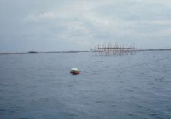
Buoy Activities in Indonesia (Imam
Mudita wrote): Starting from the research topic I have chosen for my
doctoral study program, GPS observation for sea level measurement on a
floating buoy is being investigated. During the investigation period,
a GPS buoy sea level measurements were taken on an in-house project
campaign, as part of the UPT Baruna Jaya research activities, in April
in the Bay of Jakarta. Figure 1 shows the buoy while collecting data
during the campaign.
The
data set were 15 days of continuous GPS observation in 0.5 seconds
interval. Coincident tides data during the campaign from a near tide
gauges station of PERUM PELABUHAN II were also taken. The result shows
that GPS could be used as a tool for sea level measurement if a
careful correction applied in the data processing (see Figure 2. in
yellow color) Currently,
we are trying to integrate GPS measurement with Motion Reference Unit
(MRU-5) as attitude sensor of the GPS antenna movement. We will deploy
this system in April 2001. For
the next stage, we are going to make the system in a real time mode of
observation with a reliable radio data communication and a more
sophisticated buoy construction. Instituto
de Ciencias del Espacio (CSIC), Institut d'Estudis Espacials de
Catalunya (IEEC) The
recent GPS buoy acitivies carried out at the Institute for the Space
Studies of Catalonia (IEEC) are the "GPS Radar Altimeter
Calibration" campaigns GRAC99 and GRAC2000. They had been
conducted in June 1999 and September 2000 on board a research vessel
to follow different Radar Altimeter (RA) tracks where to perform GPS
buoy and oceanographic measurements. The combined GPS and
oceanographic measurements were though to calibrate the RA sea level
estimates with the emphasis on the geostrophic currents observation
application. In
GRAC99, the GPS observations were gathered through a three-buoy
structure, specially designed for the campaign. Four time series of
GPS buoy measurements were conduceted under the ERS-1, ERS-2 and TOPEX/POSEIDON
tracks when these RA were over-flying the area. The description of
this campaign and the results are published in [1]. In
GRAC2000, a new buoy structure was constructed. It was a two-buoy
system thought to allow for a double checking approach of the
solution: on one hand the sea level form both antennas (after phase
center corrections) should be the same. On the other hand, the
distance between the buoys was constant, and its value should be
recovered from the positioning of the antennas. In
terms of data processing, the main characteristic of such GRAC
campaigns were the distance of the GPS observation from the Reference
Ground Stations, more than 80 km. Dedicated strategies to accurately
solve the vertical position were developed. GRAC99
yielded a publication, while there is a internal-project report about
GRAC2000: [1]
The Use of GPS buoys in the determination of oceanic variables,
Cardellach, E., D.Behrend, G.Ruffini, A.Rius, Earth Planets and Space,
Vol.52, pp 1113-1116, 2000. [2]
GRAC 2000 GPS Buoy Report, included in the GRAC Report, Cardellach,
E., April 2001. Contact Jordi Font, jfont@icm.csic.es for GRAC
reports. SEA LEVEL STUDIES IN TASMANIA USING GPS BUOYSChristopher
Watson (CW), Richard Coleman (RC), Tony Sprent (AS) Centre
for Spatial Information Science, University of Tasmania John
Hunter (JH), John Church (JC), il White (NW) Antarctic
CRC, University of Tasmania Sea
Level work (CW, RC, JH) The
application of GPS to localised oceanographic and geodetic experiments
has been investigated with the design and construction of a series of
GPS buoys. The buoys have been deployed at Port Arthur on Tasmania's
southeast coast as part of a long term sea level study. The GPS buoys
have be used in the determination of a precise marine geoid and they
have also been instrumental in understanding local oceanographic
phenomena (seiching) acting within the Port Arthur bay. A 1-2 day
experiment was undertaken using two GPS buoys, 6 pressure sensors and
the Port Arthur tide gauge as a way of verifying the performance of
the GPS buoys. Buoy
Design and Operation (CW, AS, RC) The
first buoy system was constructed for the Port Arthur experiment by
Chris Watson (Watson, 1999) and the buoys were simple 'wave rider'
designs similar to those developed by Kelecy et al. (1994) and Key et
al. (1997). The buoys were designed to only support the GPS antenna
and hence needed to operate close to shore or be tethered to a boat
where the GPS receiver is stored and operated. The floating platform
consisted of a section cut from a heavy-duty plastic drum, which was
braced and partially filled with polystyrene foam for buoyancy. Leica
AT202+GP antennas and custom-made perspex antenna domes were fitted to
the buoys. The buoy design is shown in Figure 1.
Figure 1. The prototype buoy design The
buoys performed well, however were limited due to their restriction of
being operated close to shore or from a boat. The design was also
quite susceptible to small surface wave activity. Following
the success of the prototype buoy, a more ruggedised version was
designed and constructed by Tony Sprent. The buoys were utilised for
further experiments at the Port Arthur site and will be used for
satellite altimeter verification experiments at the Burnie
verification site (see later). As it was aimed to measure the
instantaneous sea surface at high sampling frequencies, a wave-rider
style of buoy was still required. This will allow measurement of wave
spectra and current velocity with the ability to filter the results to
obtain the mean sea surface. The
newer buoy system was designed as a self-contained unit, with battery
power, a GPS receiver and a choke ring antenna. This removes the
previous restriction of operating the GPS from a tethered boat or from
land. The design remains readily transportable for use in local
experiments, whilst rugged enough for ocean based experiments. The
buoy consists of a central water tight, cylindrical vessel which
contains all the GPS equipment and batteries. All pieces of hardware
inside the vessel are centrally constrained to ensure the overall
construction is balanced about the central vertical axis. A removable
stainless steel frame with three Ø300mm polystyrene floats is used to
support the GPS equipment. A plan view of the buoy design with the
antenna dome removed is shown in Figure 2.
Figure 2. Plan view of the latest buoy design. The
overall radius of the buoy is 850mm. The larger weight and lower
centre of mass prevents any high frequency oscillation caused by small
wind induced surface waves. The buoy is shown in section in Figure 3.
Figure 3. The latest buoy design for the Tasmanian experiments. The
buoys have been designed to accommodate Leica CRS1000 receivers and
choke ring antennas (AT504). The dome is custom made out of 3mm 'Sunloid
KD' which is an acrylic polyvinyl chloride material. The receivers
have 64 Mb of internal memory and allow sampling rates of up to 10 Hz
allowing for most experiment scenarios. Altimeter
Calibration (JC, RC, NW, CW) The
buoys will also be deployed as part of the Jason-1 and ENVISAT
altimeter calibration activities - as well as cross-calibration with
T/P and ERS-2. Both GPS buoys will be utilised off the north west
coast of Tasmania, in Bass Strait as part of work towards a southern
hemisphere altimeter verification experiment (see White et al., 1994).
The two buoys will be positioned between 12 and 40 km from three
static GPS reference sites and an acoustic tide gauge site in Burnie
harbour. The position of the antenna phase centre relative to the mean
level surrounding the buoy is of fundamental importance for this
experiment - requirement is for accuracies at the 1 cm level. The
effect of the plastic antenna radomes needs to be further investigated
as absolute height is required. Accuracy of kinematic processing over
medium to long baselines remains the principal difficulty for these
applications. Software development has been started which is aimed at
developing algorithms specifically tuned to processing on a floating
platform. Kelecy,
T., Born, G., Parke, M. and Rocken, C. (1994). 'Precise mean sea level measurements using the Global Positioning
System', Journal of Geophysical Research, 99(C4), pp. 7951-7959. Key,
K., Parke, M. and Born, G. (1998). 'Mapping
the Sea Surface Using a GPS Buoy', Marine Geodesy, 21, pp.
67-79. Watson,
C. (1999). 'A Contribution to
Absolute Sea Level in Tasmania', Thesis for Bachelor of
Surveying with Honours, Centre for Spaital Information Science (CenSIS),
University of Tasmania, Hobart, p.
197. White,
N., Coleman, R., Church, J., Morgan, P. and Walker, S. (1994). 'A
southern hemisphere verification for the TOPEX/POSEIDON satellite
altimeter mission', Journal of Geophysical Research, 99(C12), pp.
24505-24516.
Publications
by the Members Cardellach,
E., D. Behrend, G. Ruffini, A. Rius: The Use of GPS buoys in the
determination of oceanic variables, Earth Planets and Space, Vol.52,
pp 1113-1116, 2000. Cardellach,
E.: GRAC 2000 GPS Buoy Report, included in the GRAC Report, Cardellach,
E., April 2001. Contact Jordi Font, jfont@icm.csic.es for GRAC
reports. Cheng,
K., C.K. Shum, M. Parke, K. Snow, S.C. Han, J.J. Benjamin, D. Martin,
G. Mader: "GPS-Buoy water level instrument:Applications for radar
altimeter calibration", oral presentation, GGG2000, Canada, 2000. Colombo,
O.L., A.G. Evans, M.I. Vigo, J.M. Ferrandiz, J.J. Benjamin:
"Long-baseline (>1000km), sub-decimeter kinematic positioning
of buoys at sea, with potential application to deep-sea studies",
oral presentation, ION GPS 2000, Salt Lake City, Utah, USA, 2000. Kruizinga,
G.L.H., B. Haines, J.J. Martinez-Benjamin, M. Martinez-Garcia, J.
Talaya, M.A. Ortiz, B. Perez: "The CATALA experiment, preliminary
results of ALT-B calibration using GPS buoys off the Catalonian Coast
(Spain)", ALT-B Calibration Workshop, Goddard Space Flight
Center, Greenbelt, Maryland, USA, 1999. Martinez-Benjamin,
J.J., M. Martinez-Garcia, G.L.H. Kruizinga, B. Haines, M.A. Ortiz, J.
Talaya, B. Perez, E. Alvarez, J. Garate, J.M. Davila, J.M. Ferrandiz,
M.I. Vigo-Aguiar: "The CATALA campaigns: indirect calibration
technique for ENVISAT altimeter calibration", ERS-ENVISAT
SYMPOSIUM, Gothenburg, Sweden, 2000. Martinez-Benjamin,
J.J., M. Martinez-Garcia, G.L.H. Kruizinga, B. Haines, M. Ortiz, J.
Talaya, J. Garate, J. Davila, J. Ferrandiz, M. Vigo-Aguiar, B. Perez,
E. Alvarez: "The CATALA Experiment: Absolute Calibration of TOPEX
Altimeter-B using GPS buoys in the NW-Mediterranena sea", POSTER,
The Ocean Observing System for Climate, OCEANOBS 99, St Raphael,
France, 1999. Martinez-Benjamin,
J.J., M. Martinez-Garcia, M.A. Ortiz, J. Talaya, G.L.H. Kruizinga, B.
Haines, J. Garate, M. Davila, JM. Ferrandiz, M.I. Vigo-Aguiar, B.
Perez, E. Alvarez, O. Colombo, B. Chao, CK. Shum: "The TOPEX/POSEIDON
CATALA Altimeter Calibration Campaign", POSTER, American
Geophysical Union, AGU-2000 Spring meeting, Washington, USA, 2000. Martinez-Benjamin,
J.J., M. Martinez-Garcia, M.A. Ortiz: "Validation of TOPEX/POSEIDON
GDR by independent techniques", POSTER, XXVI General Assembly of
the European Geophysical Society (EGS), Nice, France, 2001. Martinez-Benjamin,
J.J., M. Martinez-Garcia, M. Ortiz, J. Talaya, J.Garate, J. Davila, J.
Ferrandiz, M. Vigo-Aguiar, B. Perez, E. Alvarez: "The TOPEX/POSEIDON
and JASON-1 Calibration Campaigns in the Cape of Begur and Ibiza
Island Regions", POSTER, TOPEX/POSEIDON/Jason-1 Science Working
Team Meeting, Miami, USA, 2000. Martinez-Garcia,
M., G.L.H. Kruizinga, B. Haines, J.J. Martinez-Benjamin, M.A. Ortiz,
J. Talaya, J. Garate, M. Davila: "PRELIMINARY RESULTS OF THE GPS
BUOYS DATA PROCESSING IN THE NORTH WESTERN MEDITERRANEAN SEA",
POSTER, International Union of Geodesy and Geophysiscs, IUGG, 18-30
July 1999, Birmingham. Martinez-Garcia,
M., G.L.H. Kruizinga, J.J. Martinez-Benjamin, M.A. Ortiz, J. Talaya:
"Preliminary experience and technical aspects on the JASON-1
validation and calibration radar altimeter by using GPS buoys",
oral presentation, XXV General Assembly of the European Geophysical
Society (EGS), Nice, France, 2000. Martinez-Garcia,
M., J.J. Martinez-Benjamin, M.A. Ortiz: "Analysis and Strategies
applied to the GPS buoys data for the TOPEX ALT-B Absolute Calibration
in the NW-Mediterranean", POSTER, TOPEX/POSEIDON/Jason-1 Science
Working Team Meeting, Miami, USA, 2000. Martinez-Garcia,
M., J.J. Martinez-Benjamin, M.A. Ortiz: "Strategies with GPS for
the navigation of buoys", POSTER, GNSS-2001, Sevilla, Spain,
2001. Martinez-Garcia,
M., J.J. Martinez-Benjamin, M.A. Ortiz-Castellon: "Calibration
techniques applied to satellite altimeter", oral presentation,
XXVI General Assembly of the European Geophysical Society (EGS), Nice,
France, 2001. Ortiz,
M.A., M. Martinez-Garcia, J.J. Martinez-Benjamin: "GPS buoys for
altimeter calibration campaigns", POSTER, GNSS-2001, Sevilla,
Spain, 2001. Watson,
C. (1999). "A
Contribution to Absolute Sea Level in Tasmania", Thesis
for Bachelor of Surveying with Honours, Centre for Spaital Information
Science (CenSIS), University of Tasmania, Hobart, p. 197.
|
| |