INTERNATIONAL LASER RANGING
SERVICE (ILRS)
J.
J. Degnan1 and M. R. Pearlman2 1
NASA
Goddard Space Flight Center, Greenbelt, MD 20771, USA 2Harvard-Smithsonian
Center for Astrophysics (CfA), Cambridge, MA USA 02138, USA CONTRIBUTIONS
OF THE ILRS
The ILRS collects, merges, analyzes, archives and distributes Satellite
Laser Ranging (SLR) and Lunar Laser Ranging (LLR) observation data
sets of sufficient accuracy to satisfy the objectives of a wide range
of scientific, engineering, and operational applications and
experimentation. The basic observable is the precise time-of-flight of
an ultrashort laser pulse to and from a satellite, corrected for
atmospheric delays. These data sets are used by the ILRS to generate a
number of fundamental data products, including: centimeter accuracy
satellite ephemerides, Earth orientation parameters, three-dimensional
coordinates and velocities of the ILRS tracking stations; time-varying
geocenter coordinates, static and time-varying coefficients of the
Earth's gravity field, fundamental physical constants, lunar
ephemerides and librations, and lunar orientation parameters ORGANIZATION
AND ROLE OF THE ILRS The ILRS Tracking Stations range to a constellation of artificial
satellites and the Moon with state-of-the-art laser ranging systems
and transmit their data on a rapid basis (at least daily) to an
Operations or Data Center. Stations are expected to meet ILRS data
accuracy, quantity, and timeliness requirements, and their data must
be regularly and continuously analyzed by at least one Analysis or
mission-specific Associate Analysis Center. Each Tracking Station is
typically associated with one of the three regional subnetworks
(National Aeronautics and Space Administration (NASA), EUROpean LASer
Network (EUROLAS), or the Western Pacific Laser Tracking Network (WPLTN). Operations
Centers collect and merge the data from the tracking sites, provide
initial quality checks, reformat and compress the data if necessary,
maintain a local archive of the tracking data, and relay the data to a
Data Center. Operational Centers may also provide the Tracking
Stations with sustaining engineering, communications links, and other
technical support. Tracking Stations may perform part or all of the
tasks of an Operational Center themselves. Global
Data Centers are the primary interfaces between the Analysis Centers
and the outside users. They receive and archive ranging data and
supporting information from the Operations and Regional Data Centers,
and provide this data on-line to the Analysis Centers. They also
receive and archive ILRS scientific data products from the Analysis
Centers and provide these products on-line to users. Regional Data
Centers reduce traffic on electronic networks and provide a local data
archive. Analysis
Centers receive and process tracking data to produce ILRS data
products. They are committed to produce the products on a routine
basis for delivery to the Global Data Centers and the IERS using
designated standards. Full Analysis Centers routinely process the
global LAGEOS-1 and LAGEOS-2 data and provide Earth orientation
parameters on a weekly or sub-weekly basis. They also produce other
products such as station coordinates and velocities and geocenter
coordinates on a schedule consistent with IERS requirements and
provide a second level of data quality assurance in the network.
Associate Analysis Centers produce specialized products, such as
time-varying gravity field measurements, fundamental constants,
satellite predictions, precision orbits for special-purpose
satellites, regional geodetic measurements, and data products of a
mission-specific nature. Associate Analysis Centers are also
encouraged to perform quality control functions through the direct
comparison of Analysis Center products and the creation of
"combined" solutions using data from other space geodetic
techniques. Lunar Analysis Centers produce LLR products such as lunar
ephemeris, lunar libration, and Earth rotation (UT0 - UT1). In the
field of relativity, LLR is used for the verification of the
equivalence principle, estimation of geodetic precession, and
examination of the relative change in G. CENTRAL BUREAU
The ILRS Central Bureau (CB) is responsible for the daily coordination
and management of ILRS activities. It facilitates communications and
information transfer and promotes compliance with ILRS network
standards. The CB monitors network operations and quality assurance of
the data, maintains all ILRS documentation and databases, and
organizes meetings and workshops. In order to strengthen the ILRS
interface with the scientific community, a Science Coordinator and an
Analysis Specialist within the CB take a proactive role to enhance
dialogue, to promote SLR goals and capabilities, and to educate and
advise the ILRS entities on current and future science requirements
related to SLR. The Science Coordinator leads efforts to ensure that
ILRS data products meet the needs of the scientific community and
there is easy online access to all published material (via Abstracts)
relevant to SLR science and technology objectives. The CB has been actively providing new conveniences (such
as targeted email exploders) and adding to the technical and
scientific database. The information available via the ILRS Web Site
has grown enormously since its inception, and many new links to
related organizations and sites have been established. The site
provides details and photographic material on the ILRS, the satellites
and campaigns, individual SLR station characteristics, a scientific
and technical bibliography on SLR and its applications, current
activities of the Governing Board Working Groups and Central Bureau,
meeting minutes and reports (including annual reports), tracking
plans, etc. In the future, much more material will be made available
online along with an enhanced search capability to quickly isolate
specific material of interest. Due to the impending retirement of the
CB's first Director, John Bosworth of NASA , Dr. Michael Pearlman of
SAO has assumed the role of CB Director and Ms. Carey Noll of NASA
will assume Dr. Pearlman's previous role of ILRS Secretary. The
Central Bureau maintains a comprehensive web site as the primary
vehicle for the distribution of information within the ILRS community.
The site, which can be accessed at: GOVERNING BOARD AND WORKING GROUPSThe Governing Board (GB) is responsible for the general direction of the
service. It defines official ILRS policy and products, determines
satellite tracking priorities, develops standards and procedures, and
interacts with other services and organizations. There are 16 members
of the Governing Board (GB) - three are ex-officio, seven are
appointed, and six are elected by their peer groups (see Table 2). The
first GB completed its two year term in Fall 2000. A new Board was
elected over the summer and installed in November 2000 at the 12th
International Workshop in Matera, Italy. John Degnan was elected by
the current GB to serve a second two year term as Chairperson.
Table
1. ILRS Governing Board (as of May 2001) Within
the GB, permanent (Standing) or temporary (Ad-Hoc) Working Groups (WG's)
carry out policy formulation for the ILRS. At its creation, the ILRS
established four Standing WG's: (1) Missions, (2) Data Formats and
Procedures, (3) Networks and Engineering, and (4) Analysis. In 1999,
an Ad-Hoc Signal Processing WG was organized to provide improved
satellite range correction models to the analysts. The Working Groups
are intended to provide the expertise necessary to make technical
decisions, to plan programmatic courses of action, and are responsible
for reviewing and approving the content of technical and scientific
databases maintained by the Central Bureau. All GB members serve on at
least one of the four Standing Working Groups, led by a Coordinator
and Deputy Coordinator. Table 1 lists the current GB membership, their
nationality, and special function (if any) on the GB. Fortunately,
the WG's have attracted talented
people from the general ILRS membership who have contributed greatly
to the success of these efforts. The Missions WG has formalized
and standardized the mission documentation required to obtain ILRS
approval for new missions and campaigns. They continue to work with
new missions and campaign sponsors to develop and finalize tracking
plans and to establish recommended tracking priorities. The
Data Formats and Procedures WG has been tightening
up existing formats and procedures, rectifying anomalies, providing
standardized documentation through the web site, and setting up study
subgroups and teams to deal with more complicated or interdisciplinary
issues. The
Networks and Engineering WG has (1) developed the new ILRS Site and
System Information Form which is being distributed to the stations to
keep the engineering database current, (2) provided a new online
satellite-link analysis capability for system design and performance
evaluation, and (3) initiated the development of the ILRS technology
database. The Analysis WG has been working with the ILRS Analysis
Centers to develop a unified set of analysis products presented in the
internationally accepted SINEX format. Three associated pilot programs
are underway to assess differences among analysis products from the
different centers. The Signal Processing Ad-Hoc WG is working on
improved center-of-mass corrections and signal processing techniques
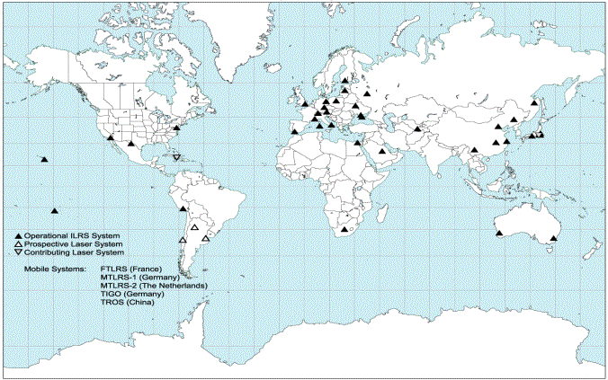
for SLR satellites. ILRS NETWORKThe ILRS Network as of May 2001 is shown in Figure 1. Traditionally the
network has been strong in the US, Europe, and Australia. Through
international partnerships, the global distribution of SLR stations is
now improving, especially in the Southern Hemisphere. NASA, working in
cooperation with CNES and the University of French Polynesia has
established SLR operations on the island of Tahiti with MOBLAS-8. In
cooperation with the South African Foundation for Research Development
(FDR), NASA has relocated MOBLAS-6 to Hartebeesthoek (which already
has VLBI, GPS, and DORIS facilities) to create the first permanent
Fundamental Station on the African continent. Both systems are
operational. . Operations at the new Australian station on Mt. Stromlo,
which replaced the older Orroral site near Canberra, are going
extremely well in terms of both data quantity and quality. The
NASA TLRS-3 system at Universidad de San Agustin in Arequipa, Peru,
has carried the total SLR tracking load for South America in recent
years. However, BKG (Germany) has selected Concepcion, Chile, for the
site of its newly developed multi-technique Totally Integrated
Geodetic Observatory (TIGO). The TIGO- with SLR, VLBI, GPS and
absolute gravimetry techniques - will provide a Fundamental Station in
South America when it becomes operational in late 2001. In Argentina,
NASA has been negotiating a possible transfer of TLRS-4 to the
University of La Plata. A possible joint Chinese-Argentine SLR station
at the San Juan Observatory in western Argentina, with SLR equipment
furnished by the Beijing Astronomical Observatory, is also being
discussed . The
Peoples' Republic of China has made substantial investment in SLR
stations and technology over the past two years. The SLR station in
Kunming was recently re-established, bringing the total number of
Chinese permanent sites to five (Shanghai, Changchun, Wuhan, Beijing,
and Kunming. The data quality and quantity from the permanent Chinese
stations continue to improve, most notably at Changchun. The Wuhan SLR
station has been recently moved to a site outside the city where there
is significantly better atmospheric seeing, and construction is
nearing completion on two mobile Chinese SLR stations which will
occupy additional sites within China, as part of a national geodetic
program. The new Russian SLR station started operations near Moscow in
1999, and permission is being requested from the Russian government to
integrate it into international SLR operations. A Russian SLR station
in Novosobirsk has recently applied for ILRS membership. Sites
in the United States and Europe have been relatively stable over the
past several years, with efforts continuing to improve overall
performance or reducing the cost of SLR operations. The new
state-of-the-art Matera Laser Ranging Observatory (MLRO) with both SLR
and lunar ranging capability has now been installed at Matera and is
presently undergoing final acceptance testing. The new French
Transportable Laser Ranging System (FTLRS) is undergoing checkout in
preparation for tracking support of JASON and other active satellite
missions from a site in the Mediterranean region. The unmanned SLR2000
prototype is nearing completion at NASA and field tests are scheduled
to begin in Fall 2001.
Figure
1. ILRS Network (as of May 2001) ILRS TRACKING PRIORITIES AND CAMPAIGNSThe ILRS is currently tracking about two dozen targets, including passive
geodetic (geodynamics) satellites, Earth remote sensing satellites,
navigation satellites, engineering missions, and lunar reflectors (see
Table 2). The newest missions include the German CHAMP mission (GFZ),
which was added in July 2000, and the oceanography mission, GFO-1 (US
Navy), which was recently elevated from campaign status to permanent
tracking. In addition, three new GLONASS (72, 79, and 80) satellites
are being tracked in support of the IGLOS campaign. Recently, Etalon 1
and 2 were elevated in priority at the request of the ILRS Analysis
Working Group in order to ascertain whether or nor SLR's determination
of Earth Orientation Parameters (EOP) could be improved. The
ILRS assigns satellite priorities in an attempt to maximize data yield
on the full satellite complex while at the same time placing greatest
emphasis on the most immediate data needs. Priorities provide
guidelines for the network stations, but stations may occasionally
deviate from the priorities to support regional activities or national
initiatives and to expand tracking coverage in regions with multiple
stations. Tracking priorities are set by the Governing Board, based on
application to the Central Bureau and recommendation of the Missions
Working Group. During
the past year, tracking campaigns have included: (1) ERS-1 to support
tandem Synthetic Aperture Radar (SAR) experiments with ERS-2; (2) the
GEOSAT Follow-on (GFO-1) altimetric mission, (3) the South African
SUNSAT remote sensing satellite, and (4) revived GEOS-3 and Beacon-C
tracking for gravity field improvement . Since
several remote sensing missions have suffered failures in their active
tracking systems or have required in-flight recalibration, the ILRS
has encouraged new missions with high precision orbit requirements to
include retroreflectors as a fail-safe backup tracking system, to
improve or strengthen overall orbit precision, and to provide
important intercomparison and calibration data with onboard microwave
navigation systems. UPCOMING MISSIONSAt one time, the main task of the international SLR Network was the
tracking of dedicated geodetic satellites (LAGEOS, Starlette, etc.).
Although we have had requests to revive tracking on older satellites
already in orbit (e.g. Beacon-C) to further refine the gravity field
with improved accuracy laser data, new requests for tracking are now
coming mainly for active satellites. The tracking approval process
begins with the submission of a Missions Support Request Form, which
is accessible through the ILRS web site. The form provides the ILRS
with the following information: a description of the mission
objectives; mission requirements; responsible individuals,
organizations, and contact information; timeline; satellite
subsystems; and details of the retroreflector array and its placement
on the satellite. This form also outlines the early stages of
intensive support that may be required during the initial orbital
acquisition and stabilization and spacecraft checkout phases. A list
of upcoming space missions that have requested ILRS tracking support
is summarized in Table 3 along with their sponsors, intended
application, and projected launch dates.
Table
2. ILRS Tracking Priorities (as of April 2001) Once
tracking support is approved by the Governing Board, the Central
Bureau works with the new missions to develop a Mission Support Plan
detailing the level of tracking, the schedule, the points of contact,
and the channels of communication. New missions normally receive very
high priority during the acquisition and checkout phases and are then
placed at a routine priority based on the satellite category and
orbital parameters. After launch, New Mission Reports with network
tracking statistics and operational comments are issued weekly. The
Central Bureau monitors progress to determine if adequate support is
being provided. New mission sponsors (users) are requested to report
at the ILRS Plenary meetings on the status of ongoing campaigns,
including the responsiveness of the ILRS to their needs and on
progress towards achieving the desired science or engineering results.
MEETINGS AND REPORTSThe ILRS organizes semiannual meetings of the Governing Board and General
Assembly, which is open to all ILRS Associates and Correspondents. The
5th ILRS General Assembly was held in November 2000 in
Matera, Italy, in conjunction with the 12th International
Workshop on Laser Ranging. The 6th ILRS General Assembly
was held in March 2001 in conjunction with the EGS Symposium in Nice,
France. Detailed reports from past meetings can be found at the ILRS
web site.
Table
3. Upcoming Missions (as of April 2001) The
7th ILRS General Assembly will be held at the Centre de
Congres Pierre Baudis in Toulouse, France, on Friday morning, 21
September 2001. The meeting is held in conjunction with the SPIE/Europto
Symposium on Remote Sensing (September 17-21, 2001), which includes a
session on Laser Radar Techniques (Sept. 17-18) as well as open ILRS
-sponsored Working Group sessions and calibration workshops A special
Joint ILRS/WPLTN symposium will be held in Riyadh, Saudi Arabia, on
the following Sunday and Monday (September 23-24). The
first ILRS Annual Report (1999) was published last year It is
available as hard copy from the CB or online at the ILRS Web Site. The
2000 ILRS Annual Report is in preparation. ILRS
Analysis Center reports and inputs are used by the Central Bureau for
weekly review of station performance and to provide feedback to the
stations when necessary. Special weekly reports on on-going campaigns
are issued by email. The CB also generates Quarterly Performance
Report Cards and posts them on the ILRS web site. The Report Cards
evaluate data quantity, data quality, and operational compliance for
each tracking station relative to ILRS minimum performance standards.
A catalogue of diagnostic methods, for use along the entire data chain
starting with data collection at the stations, has emerged from this
process and will be made available on the ILRS web site. The
evaluation process has been helpful in comparing results from
different Analysis and Associate Analysis Centers, a role soon to be
assumed by the Analysis Working Group.
|
| |