INTERNATIONAL GPS SERVICE
This
report provides an outline of the IGS activities and interim progress
report to the International Association of Geodesy for the year 2001.
The past two years have been exciting for the IGS involving many new
activities and applications in addition to the continued support to
the scientific community through GPS data and data products. The
current status and availability of IGS products is listed in the table
below.
Key
Activities in 2000-2001 The
main focus in has been promoting the use of IGS data and products as
the accepted international standard and expanded outreach to
developing countries. This is evidenced by the IGS tutorial
development, exhibits at conference and workshop venues and developing
the IGS User Forums. A main activity of the IGS Governing Board (GB)
since late 1999 is a strategic planning effort. The motion to develop
a plan was approved at the June 2000 meeting of the GB and resulted in
the establishment of a strategic planning committee. This committee
worked with an experienced facilitator retained by the Central Bureau
(CB). This committee followed a planning process and prepared
necessary information for the full retreat of the GB in December,
2000. This was a very worthwhile effort and the final documents will
be complete by June of 2001. Issues addressed by the GB include a
review of the IGS Mission, IGS long-term goals and the key strategic
actions to accomplish these goals. It is expected that there will be
consensus to obtain an official recommitment to the IGS from
participating organizations and to attempt to gain stable support from
sponsoring agencies. The IGS seeks IAG support of the IGS plan and its
implementation. Increasing
involvement in realizing a modern continental geodetic reference
system for Africa, 'AFREF'. This will be of great benefit to the
African nations and may enable greater geodetic GPS densification of
this vast area, The most effective way to achieve such continental
reference system that is robust and globally consistent is through GPS
technology and the economics of GPS make this the technique of choice
for sustainable geodetic operations within Africa. This activity is
advocated by the IAG, IAG Commissions X and the IGS. Chair
of the IGS GB since 1994, Prof. Gerhard Beutler of the University of
Bern, Switzerland was succeeded by Prof. Christoph Reigber of
theGeoForschunZentrum, Postdam Germany at the December 1999 meeting.
In 1999 the IGS Governing Board also established the position of the
IGS Reference Frame Coordinator, filled by Dr. Remi Ferland of the
Natural Resources of Canada. 1999 saw the retirement of Governing
Board members who had each been instrumental in the early orgnization
of the IGS and its rapid growth: Prof. Yehuda Bock, Dr. Jan Kouba, IGS
Analysis Coordinator from 1993 - 1998, Dr. Bill Melbourne, and Prof.
Ivan Mueller. Mueller and Melbourne were involved in the IGS planning
Committee, led by Mueller and established in 1990. IGS
Working Groups, Pilot Projects Applications
of GPS extend beyond the fundamental processes of the IGS. These
activities which are very reliant on the IGS for realization, but are
not yet a core compnent of the IGS are organized into working groups,
pilot projects or committees. These
currently include:
More
details on each of these activities can be found in the Annual and
Technical Report Series of the IGS, and workshop proceedings, all
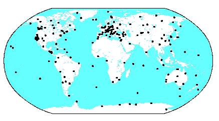
available at the IGS website or through the IGS Central Bureau. IGS Network
During
the past two years, the International GLONASS Pilot Project (IGLOS-PP)
has been developing and is now officially recognized within the IGS
adding an additional class of station and processes to the IGS
infrastructure. GLONASS is being moved towards full integration into
the GPS-based IGS. This is a key extension of the IGS and establishes
a precedent that the service is poised to unify observations and
product development of similar satellite microwave techniques,
including the future Galileo & potential GNSS. Another
growing strength in IGS is utilizing the increasing number of stations
providing hourly uploads of data files to the IGS data centers. Now
approximately 60 stations provide data hourly to the data centers,
permitting the IGS analysis centers to processing observations more
rapidly and to successfully move from daily orbit generation to
sub-daily generation. This is currently twice daily and moving towards
3 to 4 times daily in the near future. This is vital for providing
more rapid products to users, and decreasing the time to access
ultrarapid orbits. This more rapid turn around results in less aging
of the predicts, and thus the available precision now approaches 25 cm
3-dimensional weighted rms. level (3d-wrms) a great improvement over
daily products for time critical applications. In any case, IGS Final
orbits remain consistent at the 5cm 3d-wrms.. Outreach and
Exhibit
The
Central Bureau completed design of an exhibit booth in early 2000 for
displaying and providing information to attendees of scientific forums
and conferences. All publications of the IGS are displayed.
Publication requests are available at each venue and accessible on the
web as well. The new IGS exhibit is also designed to be extremely
portable so that it can be shipped to other IGS colleagues who can
host the exhibit at various venues. During the past two years the
exhibit was displayed at the 28th International Symposium on Remote
Sensing of the Environment (ISRSE) in Capetown, South Africa; INTERGEO
Conference in Berlin, Germany; at the GPS Annual Conference of the
Institute of Navigation (ION) in Salt Lake City, USA; AGU 2000 Fall
meeting in San Francisco, USA, CONSAS, South Africa, and the EGS in
Nice, March 2001. In
1999 and 2000 a great deal of time and effort were devoted to
developing a tutorial of the IGS describing in details all components.
A number of people were responsible for contributing to the contents
of this tutorial. The tutorial was divided into the following sections
reflecting the various components of the IGS:
It
requires nearly six hours to provide the tutorial in present scope.
Evaluations indicate that this has been very well received and we
intend to keep it current and further develop the contents. Two areas
yet to be developed include a section on ‘How to Use IGS Products’
and additional subsections on the key applications — the focus of
the working groups and pilot project in the IGS (atmospherics,
ionosphere, time transfer, sea level, etc.). IGS
Meetings and Workshops 2000-2001 July
2000: IGS Network Workshop, Oslo, Norway was organized joint with COST
Action 716, ‘Exploitation of Ground-Based GPS for Climate and
Numerical Weather Prediction Applications’ hosted locally by Statens
Kartverk, the Norwegian Mapping Authority. This was a key workshop to
review state of IGS infrastructure and plan future actions based on
directions of the IGS analysis requirements and projects. September
2000: IGS Analysis Center Workshop US Naval Observatory, Washington
DC, first two days devoted to aspects of the IGS Pilot Project on
Precise Time and Frequency joint with BIPM. Analysis workshop devoted
to the technical details of maintaining state of the art products.
Also September, ION GPS 2000 Salt Lake City, CB hosted an Exhibit, and
a Users Forum . December
2000: Organized IGS Strategic Planning session and Governing Board
meeting in Napa Valley, California, hosted IGS Exhibit and other
meetings at the AGU in San Francisco. February
2001: Low Earth Orbiter Pilot Project Organization Workshop, held at
GeoForschungsZentrum, Potsdam, Germany. October
2001: "Towards Real Time", IGS Workshop to be held in Ottawa
Canada, October 15-18, hosted by Natural Resources of Canada.
Related
Links http://www.cx.unibe.ch/aiub/acc.html http://igscb.jpl.nasa.gov/organization/centers.html http://igscb.jpl.nasa.gov/overview/links.html
|
| | |||||||||||||||||||||||||||||||||||||||||||||||||||||||||||||||||||||||||||||||||||||||||||||||||||||||||||||||||||||||||||||||||||||||||||||||||||||||||||||||||||||||||||||||||||||||||||||||||