
IAG - CDC
(International Association of Geodesy - Committee for Developing Countries)
REPORT
1999 - 2003
(Report prepared by D. Blitzkow and E. S. Fonseca Jr.)
(Contributions from: Charles Merry and John Manning)
XXIII General Assembly of the
International Union of Geodesy and Geophysics
Sapporo - Japan
June 30 July 11, 2003
IAG - CDC REPORT
(1999 2003)
IAG - CDC (International Association of Geodesy/Committee for Developing Countries)
XXIII General Assembly of the International Union of Geodesy and Geophysics
Sapporo Japan / June 30 July 11, 2003
1. History
During the General Assembly in Vienna, August 1991, the IUGG (International Union of Geodesy and Geophysics) requested to each of its constituent associations to reinforce actions towards Developing Countries. For this reason the IAG Executive Committee, at its meeting in Columbus, March 1992, set up an IAG Committee for Developing Countries (IAG - CDC). The committee had several activities on the coordination of Michael Louis. With his retirement the activities have been discontinued. At the EC meeting in Como, November 1999, a proposal by the president has been approved to restart the activities of IAG - CDC under the coordination of Denizar Blitzkow.
2. Objectives
2.1 To encourage and to facilitate present participation of developing countries in geodetic activities with a significant contribution to their own development as well as to the development of geodesy in general.
2.2 To request all IAG bodies and organizations to take into account, in their activities, the needs and capabilities of developing countries in order to ensure a profitable participation of them.
3. IAG - CDC Membership
Denizar Blitzkow (Brazil) - Chairman
Edvaldo Simões da Fonseca Junior (Brazil)
J.Y. Chen (China)
Charles Merry (South Africa)
Salah Mahmoud (Egypt)
Salem Kahlouche (Algeria)
José Napoleon Hernandez (Venezuela)
John Manning (Australia).
4. General Information - Activities (1999 2003)
Many activities and happenings have occurred in different countries in the last four years with important contributions to developing countries.
4.1 South America
4.1.1 Gravity Surveys
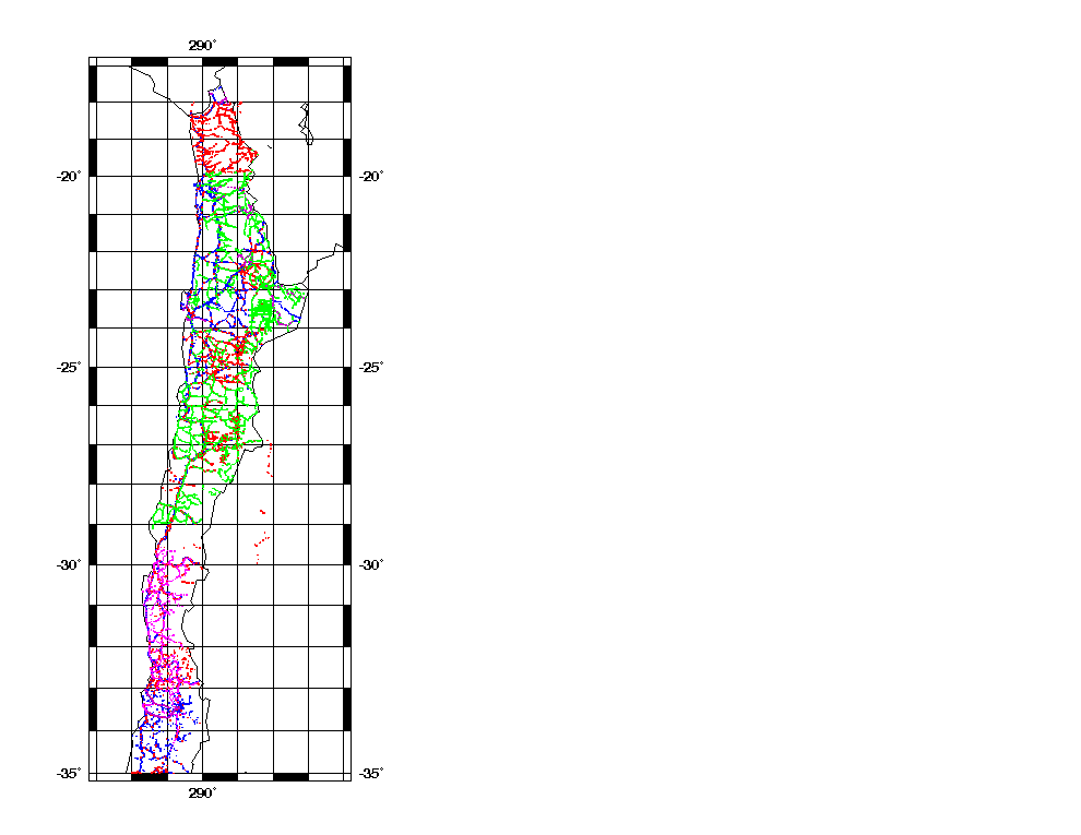
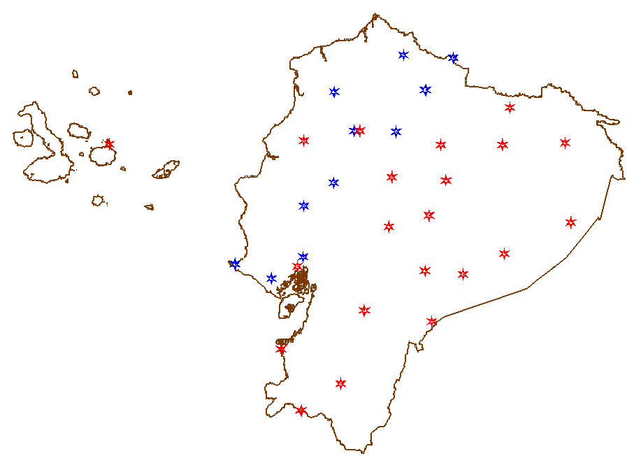
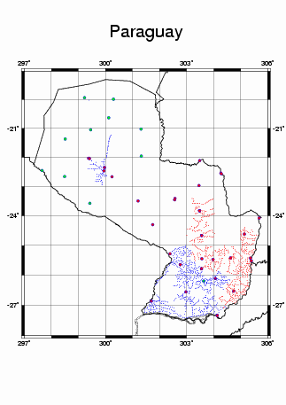
Gravity activities related to the establishment of fundamental gravity network as well as densification surveys have been carried out in several countries during the last few years. The following countries have improved the gravity coverage due to these actions: Argentina, Brazil, Chile, Equator, and Paraguay.
This initiative has been coordinated by D. Blitzkow and supported by NIMA (USA), GETECH (University of Leeds UK), and many national organizations in the different countries. As a consequence, several improved versions of the geoid have been derived for the continent as an effort of EPUSP/IBGE and with some particular cooperation like IGeS (International Geoid Service) and recently GFZ ( GeoForschungsZentrum). Some countries are carrying out particular efforts to compute their own geoid model, like Argentina, Brazil, Colombia, Uruguay and Venezuela.
4.1.1.1 Argentina
A total of 22,554 gravity points were acquired from different sources: Instituto Geográfico Militar, Universidad Nacional de La Plata, Universidad Nacional de Buenos Aires, Universidad Nacional de Tucumán, Instituto Antártico Argentino, Universidade de Potsdam (H. Goetze).
All gravity values have been adjusted to IGSN71 by using "Latin American Gravity Standardization Net 1977".
After a validation process was completed, terrain correction, Free Air and Bouguer anomalies were computed and referred to WGS-84 through the corresponding theoretical formula.
4.1.1.2 Brazil
Gravity surveys being done in Brazil in the last ten years and validation in the last five years.
Cooperation between EPUSP/IBGE with the support of NIMA and GETECH.
Gravity data received from many other organizations:
The total number of gravity stations presently available in Brazil is: 472,535
![]()
4.1.1.3 Chile


4.1.1.4 Equator
 Local organization involved: IGM, INOCAR
4.1.1.5 Paraguay
Number of points: 1,762

4.1.2 TIGO Project
The TIGO (Transportable Integrated Geodetic Observatory) is a project of cooperation that involves the following organization in Germany and Chile: Bundesamt für Katographie und Geodäsie, Universidad de Conception, Universidad del Bio Bio, Universidad Catolica de la Santissima Conception and Instituto Geografico Militar (IGM). The following technologies or facilities are available at the site, in Conception, since 2000:
More information can be obtained at the following site: www.wettzell.ifag.de/tigo/
4.1.3 Workshop: South America Geoid 2000
The South America Geoid 2000 workshop held at Escola Politécnica, Universidade de São Paulo, May 17 - 19, 2000, was organized by IGeS (International Geoid Service), SCGGSA (Sub-Commission for Gravity and Geoid in South America), CDC (Committee for Developing Countries) and was also supported by IAPSO (International Association of the Physical Science of the Ocean).
IAG-CDC Participation: D. Blitzkow, R. Barzaghi, O. Andersen and R. Forsberg.
4.1.4 IAG Symposium Vertical Reference System (VeReS)
The VeReS Symposium was organized by the Instituto Geográfico Agustín Codazzi (IGAC), Bogotá and held in the city of Cartagena Colombia, from February 20 to 23, 2001. Besides IAG and Pan-American Institute of Geography and History (PAIGH), the UNESCO Division of Earth Sciences and the German Carl Duisberg Gesellschaft sponsored the symposium.
4.1.5 SIRGAS Project
In April, 2003 the Central Bureau of SIRGAS (Geocentric Reference System for the Americas) under the coordination of Luiz Paulo Souto Fortes as the president, presented the SIRGAS 2000 campaign final coordinates as well as their accuracy estimates. These results were generated by DGFI (Deutsche Geodätische Forschungsinstitut), from the individual results of the two processing centres: DGFI, in Munich, Germany, and IBGE, in Rio de Janeiro, Brazil. The results can be fund at: www.ibge.gov.br/sirgas
4.2 Africa
4.2.1 African Reference System (AFREF): Southern Africa
Representatives of 8 countries in Southern Africa met in Cape Town on the 13th and 14th of March 2001 to discuss a regional project within the broader AFREF project to create a uniform geodetic reference system for Africa. The 8 countries present were: Botswana, Malawi, Mozambique, Namibia, South Africa, Swaziland, Zambia and Zimbabwe.
IAG Participation: Sansò, F., Neilan, R..
4.2.2 Organization of Africa gravity data for geoid computation
The purpose of this project is to carry out a determination of the geoid in Africa. A major part of the project will be to collate and merge gravity anomaly data sets for Africa. Because of the paucity of these data and their poor distribution, the geoid that will result wont be very precise, but it should still be a substantial improvement over the global EGM96 model. An equally important part of the project will be to develop geoid computation expertise within Africa.
To do the African Geoid a working group was created with the following objectives:
IAG - CDC Coordination: C. Merry, D. Blitzkow.
4.2.3 2nd Workshop on the definition of the North African Reference Frame (2° Atelier Nord Africain de Géodésie)
Representatives of the following countries participated to the workshop: Algeria, Libya, Morocco, Mauritania and Tunisia.
During the workshop a project was created to unify the Geodetic Reference Frame in North Africa (NAFREF).
IAG - CDC Participation: F. Sansò, Z. Altamimi, M. Sarrailh, S. M. Alves Costa.
4.3 Asia and the Pacific region
The UN definition of the Asia Pacific region includes 55 countries, many of which can be regarded as developing countries. Under the UNRCC banner a Permanent Committee for GIS Infrastructure in Asia and the Pacific (PCGIAP) has been established which comprises the heads of national surveying and mapping organisations . This in turn has a Regional Geodesy Working Group to coordinate regional geodesy issues. As this group has widespread representation from national surveying and mapping agencies it was sensible to link these common activities to the IAG Commission X Sub Commission for SE Asia and the Pacific and to provide input for the Sub Commission for Developing Countries, to as a regional coordinating group operating at the national agency level.
Geodetic development activity on a regional scale has continued to be undertaken by the PCGIAP Regional geodesy Working Group of the UN PCGIAP since it was formed in 1996. However there has been no specific IAG sponsored activity in the Asia Pacific since the excellent Geoid school held in Malaysia in March 1999, although IAG gave an address on global and regional perspectives to the 15th UNRCC in Kuala Lumpur in April 2000.
More detailed activities of the Regional Geodesy working group in relation to the regional geodetic infrastructure are reported separately through the South Asia and Pacific Sub commission of Commission X. General activities of the group are given in the PCGIAP web site (pcgiap.org). ITRF has been endorsed as the regional horizontal datum and as the regional reference ellipsoidal surface for vertical datums. Guidelines for development of transformation parameters have been prepared and posted to the web site for use by individual countries.
There were a number of face to face meetings held during the period. These are essential to maintain contact and to progress work on projects. These included the following events:
The next meeting of the PCGIAP Regional Geodetic Working Group will be hosted by Japan during the 16th UNRCC-AP meeting in Okinawa 14th-18th July 2003 and the next regional field campaign will be held in October 2003. Annual Geodetic workshops are planned for 2003,2004 and 2005 and IAG support for these events would be welcome.
Key development problems in the region remain :
These problems are magnified in the Pacific region and also in the West and Central Asian countries. The lack of individual membership to IAG is an impediment for technology transfer through participation in IAG activities for developing countries and IAG needs to do more in the region to promote its activities.
Within PCGIAP development needs relating to spatial data are now the responsibility of the Institutional Strengthening Working Group currently headed by the Philippines which undertook a needs analysis of the 17 pacific island nations in 1999 following a spatial data workshop in Suva. This identified geodesy as a prime requirement for the Pacific region at that time and this is still applicable.
Australia has installed ten continuous GPS base stations throughout the Western Pacific and is working jointly with the local persons to transfer GPS technology and to send daily data from the base stations for sea level monitoring. This provides a very useful tool for local geodesy application. In addition the AUSPOS on line GPS processing is providing a significant benefit across the region in computing centimetre level positions in ITRF for those with dual frequency GPS equipment.
The geodetic activities of the Central Asia States (the former Soviet states) are coordinated to PCGIAP through Russia whilst the pacific nations are coordinated through a pacific sub group currently chaired by the Cook Islands.
IAG assistance in education, equipment access and non-monetary endorsement of regional meetings and activities would be greatly appreciated. The region is tectonically complex (producing many related geo hazards) and in need of better land and marine geoids. As it covers such a large part of the globe its role in the IGGOS needs special consideration.