Special Study Group 2.161 Report Report
Probing the Atmosphere by GPS
Christian Rocken
COSMIC Program Office University Corporation for
Atmospheric Research (UCAR)
Boulder, CO., 80301 USA
Introduction
It is now well established that space-based Global Positioning
System (GPS) receivers can be used to profile Earth's ionosphere and neutral
atmosphere with high accuracy and vertical resolution. The first proof-of-concept
mission has been successfully completed and its data have been analyzed.
Two follow-on missions have been launched during the first half of 1999
and a series of more ambitious missions to profile the atmosphere using
the GPS limb sounding technique are planned for launch within the next
4 years. This report summarizes the dramatic progress in space-borne profiling
during the last several years. We will review the most important results
and accomplishments from the proof-of-concept GPS/MET mission; summarize
future GPS occultation missions and challenges, and discuss applications
of these data to meteorology, space weather, and climate studies.
GPS/MET
Scientists at Stanford University and the Jet Propulsion
Laboratory (JPL) developed the radio occultation sounding technique for
the remote sensing of planetary atmospheres. The GPS/MET (GPS/Meteorology)
program was established by the University Corporation for Atmospheric
Research (UCAR) in 1993, jointly with the University of Arizona and JPL,
to demonstrate active limb sounding of the Earth's neutral atmosphere and
ionosphere using the radio occultation technique. The demonstration system
observed occulted GPS satellite signals received on a LEO satellite, MicroLab-1
(ML-1), launched April 3, 1995. From raw GPS/MET observations, vertical
profiles of ray bending angle and refractivity were retrieved; from which
ionospheric electron density, neutral atmospheric density, pressure, temperature,
and moisture profiles were computed. The program has been exceptionally
successful, having accomplished nearly all of the proof of concept goals,
plus a number of additional ones. As a direct result, GPS/MET technology
is now widely recognized as a potential candidate for a new, accurate global
observing system in support of weather prediction, climate change research
and space weather. Several groups at JPL, the University of Arizona, UCAR,
the Danish Meteorological Institute (DMI), the University of Graz, the
Geoforschungszentrum, Potsdam (GFZ), the Institute of Atmospheric Physics,
Moscow (IAP), the Institut d'Estudies Espacials de Catalounya, the University
of Kyoto, and others, developed data inversion and analysis software for
the GPS/MET data. In addition to studies based on GPS/MET data, a team
at Stanford University conducted detailed investigations on error sources
affecting the occultation technique. Studies on the assimilation of occultation
data into numerical atmospheric models were conducted primarily at the
National Center for Atmospheric Research (NCAR), Florida State University
(FSU), the National Center for Environmental Prediction (NCEP), and the
Max Plank Institute (MPI). The participation in GPS/MET and the use of
its data was much broader than originally anticipated when the special
study group (SSG2.161) on atmospheric sounding with GPS was formed at the
1995 IUGG in Boulder, Colorado.
A summary of key GPS/MET results based on studies by these
groups from research institutions all over the world is presented in the
following table:
 |
62,000 neutral atmospheric soundings were processed to level
1 (GPS phase, range and amplitude data), 11,000 processed to Level 3 (high-resolution
profiles of temperature, pressure, refractivity, humidity, geopotential
height) and published on the web for A/S on and A/S off time periods. Several
thousand soundings were compared to data from independent operational weather
analyses and other observing systems. |
|
|
The high theoretical temperature accuracy was verified (approximately
1K) in the range from the surface to 40 km.
|
|
Accurate retrieval of water vapor was demonstrated with use
of ancillary temperature data.
|
|
High vertical resolution of approximately 500 m for sensing
of the tropopause and upper level fronts was demonstrated.
|
|
New processing techniques were developed to reduce diffraction
and multipath effects and to improve the vertical resolution beyond the
Fresnel zone limit.
|
|
All weather (including aerosols, clouds and precipitation)
sounding capability was verified.
|
|
Determination of accurate geopotential heights of ~10 m was
demonstrated.
|
|
Detection of gravity waves from the middle troposphere to
the stratosphere was demonstrated
|
|
Over 40,000 electron density profiles were processed and
compared to ionosonde data
|
|
Techniques were developed to account for horizontal gradients
in the electron density distribution
|
|
Accurate retrieval of vertical electron density profiles
was demonstrated by ~10% level agreement with foF2 frequency data from
the global ionosonde network
|
|
Tomographic techniques were developed and tested to combine
occultation data and ground based GPS observations to reconstruct global
4-D electron density grids.
|
|
GPS/MET orbit data were used in the development of the new
Earth Gravitational Model EGM96 (Lemoine et al., 1998).
|
|
Observing systems simulation experiments and real-data assimilation
experiments have indicated a likely positive impact of GPS/MET data on
model initialization and weather prediction.
|
|
A total of 123 data use agreements were issued for access
through the GPS/MET web site, which still receives about 40,000 "hits"/month
(http://cosmic.gpsmet.ucar.edu/gpsmet).
|
|
The data have been used extensively and internationally for
science and planning of follow-on missions.
|
|
A large number of peer-reviewed publications have been written
using the GPS/MET data.
|
All of these accomplishments were achieved by scientists
world-wide independently and in collaboration during the last 4 years -
a truly remarkable advancement in atmospheric and occultation science.
The extensive list of references at the end of this report points to detailed
descriptions of this work.
Below is a list of names and email addresses of the individuals
that are part of the special study group and/or contributed to the scientific
results summarized in this report. Many others made significant contributions
and this is not a complete list.
Anderson, David <danderson@sec.noaa.gov>
Mette Mortensen MDM@dmi.dk
Mike Watkins mmw@cobra.jpl.nasa.gov
Chris Reigber reigber@gfz-potsdam.de
Antoni Rius rius@ieec.fcr.es
Michael Gorbunov gorbunov@dkrz.de
Norbert Jakowski jakowski@nz.dlr.de
Luis Kornblueh kornblueh@dkrz.de
Giulio Ruffini ruffini@ieec.fcr.es
Toshitaka Tsuda tsuda@kurasc.kyoto-u.ac.jp
Per Hoeg hoeg@dmi.min.dk
Tom Yunck Thomas.P.Yunck@jpl.nasa.gov
Rob Kursinski erk@cobra.jpl.nasa.gov
Gerry North northead@ariel.met.tamu.edu
Alejandro Flores flores@ieec.fcr.es
Sergey Sokolovskiy sergey@ucar.edu
Bill Kuo kuo@ucar.edu
Ben Herman herman@air.atmo.arizona.edu
Bill Melbourne william.g.melbourne@jpl.nasa.gov
Chris Rocken rocken@ucar.edu
Francois Vandenbergh vandenb@ucar.edu
George Hajj George.A.Hajj@jpl.nasa.gov
Joan Alexander alexand@colorado-research.com
Larry Young Lawrence.E.Young@jpl.nasa.gov
Xiaolei Zou zou@bergeron.met.fsu.edu
Rick Anthes anthes@ucar.edu
Gottfried Kirchengast gottfried.kirchengast@kfunigraz.ac.at
The next Missions
The next table provides a list of mission names, their
launch dates, number of daily soundings, and a comment about the most important
aspect of the occultation part of the mission. Note that for most of these
missions the GPS atmospheric sounding instrument is just one of many experiments
and that the primary objective of these missions is generally not atmospheric
sounding.
|
Mission Name
|
Launch Date
|
# of daily profiles
|
comment
|
|
GPS/MET
|
April 1995
|
125
|
Proof of concept
|
|
Ørsted
|
Feb 1999
|
125
|
Similar GPS receiver as GPS/MET
|
|
Sunsat
|
Feb. 1999
|
125
|
Similar GPS receiver as GPS/MET
|
|
CHAMP
|
Jan. 2000
|
250
|
Improved GPS tracking receiver
|
|
SAC-C
|
Jan. 2000
|
500
|
Setting and rising occultations
|
|
GRACE
|
May 2001
|
500
|
|
|
COSMIC
|
Nov. 2002
|
4000
|
Operational demonstration
|
|
METOP
|
2003
|
500 - 1000
|
May track GLONASS plus GPS
|
|
Ørsted was successfully launched in Feb. 1999.
It is managed by the DMI and carries a JPL-developed GPS receiver that
is a slightly refined version of the GPS/MET instrument. The receiver uses
less power than GPS/MET has better data compression and some performance
enhancements. This receiver only tracks setting GPS occultations and its
data quality is strongly degraded (as was the case for GPS/MET) when the
GPS signals are encrypted by Anti Spoofing measures (A/S), which is presently
the normal mode of operation. The main purpose of the GPS soundings collected
by Ørsted is its use for climate research and to advance the occultation
technology. |
|
Sunsat is a South African mission that is flying the
same GPS receiver as Ørsted. |
|
CHAMP is a German mission that will fly an enhanced
JPL-developed receiver, called "BlackJack". The main advantage of this
next generation receiver is a 3-dB signal-to-noise ratio (SNR) improvement
over the previous tracking techniques under weak signal conditions. It
is expected that this receiver will surpass the GPS/Met A/S off tracking
performance even when A/S is on. Thus this receiver will track the occultation
signal more reliably in the lower troposphere than its predecessors. |
|
SAC-C is an Argentine led mission that will use the
same GPS instrument as CHAMP. SAC-C will be the first mission to attempt
tracking setting and rising occultations. Tracking of rising occultations
is more demanding because the receiver needs to pick up faint signals from
behind Earth's limb as the GPS satellite appears in the (approximate) direction
of the low earth orbiter's velocity vector. |
|
GRACE is a U.S./German mission that will fly a JPL-developed
receiver with added capability to track a Ka-band crosslink ranging signal
between the two GRACE satellites and to determine precise attitude from
an integrated digital star camera. |
|
COSMIC is Taiwan/U.S. mission that will fly 8 satellites
to measure 4000 soundings each day globally. The main goal of COSMIC is
to demonstrate the operational value of occultation data to numerical weather
prediction and space weather monitoring. To achieve this goal the data
from this mission shall be analyzed and delivered to operational and research
centers worldwide within 3 hours of data collection. COSMIC plans to fly
JPL-developed receivers adapted from the "BlackJack" generation instrument. |
|
METOP is a European operational satellite that will
carry a European - developed GPS/Glonass receiver. METOP occultation data
will be used for operational weather prediction. |
Applications and Challenges
The main characteristics of space-based GPS atmospheric
sounding data and their applications are summarized below.
|
Characteristic
|
Meteorology
|
Climate
|
Ionosphere
|
|
Limb sounding geometry complementary
to ground and space nadir viewing instruments
|
X
|
X
|
X
|
|
High Accuracy
|
X
|
X
|
X
|
|
High vertical resolution
|
X
|
X
|
X
|
|
Consistency of horizontal and
vertical scales of observations
|
X
|
X
|
|
|
All weather-not affected by clouds
or precipitation
|
X
|
X
|
X
|
|
Independent height and pressure
|
X
|
X
|
|
|
Requires no first guess sounding
|
X
|
X
|
X
|
|
Independent of radiosonde or other
calibration
|
X
|
X
|
X
|
|
No instrument drift
|
|
X
|
|
|
No satellite-to-satellite bias
|
|
X
|
|
|
Top and bottom side sounding
|
|
|
X
|
Because of these characteristics occultation data have the
potential to significantly benefit meteorology, climate and ionospheric
research and forecasting. In order to achieve these benefits the community
has to (a) collect a large amount of high quality occultation data, and
(b) develop the techniques to assimilate these observations into physical
models of the atmosphere and ionosphere.
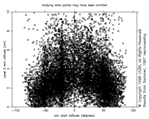
Figure 1 GPS Sounding penetration for ~10,000 GPS/MET
occultations as a function of latitude
The upcoming missions promise to provide the needed data
volume and density to demonstrate forecasting impact. In addition to more
data, the data from these missions will also have to be of higher quality
than what was produced by GPS/MET. Figure 1 shows the depth to which GPS/MET
occultations penetrated Earth's atmosphere. It can be seen that most occultation
stopped as high as 3 km above the surface and in the equatorial region
hardly any soundings probed the lowest km. It is of the highest importance
that future missions provide data that reliably penetrate to near the surface.
This shall be achieved with a combination of improved GPS occultation instruments
and higher gain antennas flown in future missions.
New and improved algorithms will also have to be developed
to deal with lower tropospheric data that will be affected by strong refractivity
gradients due to water vapor.
Summary
The research community has made impressive gains over
the last 4 years in the field of atmospheric sounding from space with GPS.
New satellite missions will provide much more data in the near future and
we can look forward to witnessing improvements in weather and space weather
forecasting due, in part, to this sensing technique. Important challenges
lie ahead to collect and correctly interpret data near the ground, and
to develop optimal data assimilation techniques.
References
Ahmad, B., Accuracy and Resolution of Atmospheric
Profiles Obtained from Radio Occultation Measurements, Ph.D. Dissertation,
Stanford University, December, 1998. Also available as Scientific Report
No. DPD811-1998-1, Space, Telecommunications, and Radio Sci. Laboratory,
Department of Electrical Engineering, Stanford University, California,
94305-9515, October, 1998.
Ahmad, B., and G. L. Tyler, The two-dimensional resolution
kernel associated with retrieval of ionospheric and atmospheric refractivity
profiles by Abelian inversion of radio occultation phase data, Radio
Sci., 33, (1), 129-142, 1998.
Ahmad, B., and G. L. Tyler, Systematic errors in atmospheric
profiles obtained from Abelian inversion of radio occultation data: Effects
of large-scale horizontal gradients, J. Geophys. Res., 104(D4),
3971-3992, 1999.
Anderson, J., and G. North, Testing climate models: An
approach. Bull. Amer. Met. Soc., 79, 2541-2549, 1998.
Anthes, R., M. Exner, C. Rocken, and R. Ware, Results
from the GPS/MET Experiment and Potential Applications to GEWEX, GEWEX
News, 7, 1997.
Anthes, R., W. Schreiner, S. M. Exner, D. Hunt, Y. Kuo,
S. Sokolovskiy, R. Ware and X. Zou, GPS Sounding of the Atmosphere from
Low Earth Orbit: Preliminary Results and Potential Impact on Numerical
Weather Prediction, Augmenting the GPS Infrastructure for Earth,
GPS for the Geosciences, National Academy Press, pp.114-124,
1997a.
Belloul, B. and A. Hauchecorne, Effect of periodic horizontal
gradients on the retrieval of atmospheric profiles from occultation measurement.
Radio Sci., 32(2), 469-478, 1997.
Bengtsson, L., J.R. Eyre, G. Kirchengast, A. Hauchecorne,
P. Silvestrin, and P. Ingmann, Atmospheric Profiling Mission --- a candidate
Earth Explorer mission (report for assessment), ESA Spec. Publ. SP-1196
(7), 58 p., ESA/ESTEC, Noordwijk, NL, 1996.
Bertiger, W., and S.C. Wu, Single Frequency GPS Orbit
Determination for Low Earth Orbiters, paper presented at the National Technical
Meeting, Inst. Of Nav., Santa Monica, Calif., Jan., 1996.
Businger, S., S. Chiswell, M. Bevis, J. Duan, R. Anthes,
C. Rocken, R. Ware, M. Exner, T. VanHove, and F. Solheim, The promise of
GPS in atmospheric monitoring, Bull. Amer. Met. Soc., 77,
5-18, 1996.
Dymond, K., S.E. Thonnard, R.P. McCoy, and R.J. Thomas,
An optical remote sensing technique for determining nighttime F region
electron density, Radio Sci., 32(5), Sept., 1997.
ESA, 1996: Atmospheric Profiling Mission. ESA SP-1196(7).
The Nine Candidate Earth Explorer Missions. European Space Agency, ESA
Publications Division, Noordwijk, The Netherlands, 58.
Feng, D., B. Herman, M. Exner, B. Schreiner, R. Anthes,
and R. Ware, Space-borne GPS remote sensing for atmospheric research,
Proceedings from Synthetic Aperture Radar and Passive Microwave Sensing,
2584, 448-455, 1995.
Fjeldbo, G., A. J. Kliore, and V. L. Von Eshelman, The
neutral atmosphere of Venus as studied with the Mariner V radio occultation
experiments, Astron. J., 76, 123-140, 1971.
Flores A., G.Ruffini, A.Rius, Tropospheric tomography
using GPS slant delays, submitted to Geophys. Res. Lett.,
1998.
Foelsche, U., and G. Kirchengast, Space-Time resolution
conditions for atmospheric imaging involving GNSS occultation: A quantitative
study, IMG/UoG Techn. Rep. for ESA/ESTEC No. 3/'97, 33 p., Inst.
Meteorol. Geophys., Univ. Graz, Austria, 1997.
Gorbunov, M. E., Solution of inverse problems of remote
atmospheric refractometry on limb paths, Izv Acad. Sci. USSR:
Atmos. Oceanic Phys., Engl. Transl., 26, 86-91, 1990.
Gorbunov, M., and S. Sokolovskiy, Remote sensing of refractivity
from space for global observations of atmospheric parameters, Rep. 119,
58 pp., Max Planck Inst. for Meteorol., Hamburg, Germany, 1993.
Gorbunov, M. E., A. S. Gurvich, and L. Bengtsson, Advanced
algorithms of inversion of GPS/MET satellite data and their application
to reconstruction of temperature and humidity, Rep. 211, 40 p.,
Max Planck Inst. for Meteorol., Hamburg 1996.
Gorbunov, M.E., S. V. Sokolovsky and L. Bengtsson,: Space
refractive tomography of the atmosphere: Modeling of direct and inverse
problems. Rep. 210, 59, Max Planck Inst for Meteorol., Hamburg,
1996a.
Gorbunov, M.E., and A.S.Gurvich, Microlab-1 Experiment:
Multipath effects in the lower troposphere, J. Geophys. Res., 103,
(D12), 13819-13826, 1998.
Gurvich, A. S., and S. V. Sokolovskiy, Reconstruction
of a pressure field by remote refractometry from space, Izvestya, Atm.
Ocean. Phys., 21, 7-13, 1983.
Hajj, G. A., and L. J. Romans, Ionospheric electron density
profiles obtained with the Global Positioning System: Results from the
GPS/MET experiment, Radio Sci., 33(1), 175-190, 1998.
Hajj, G. A., R. Ibanez-Meir, E. R. Kursinski, and L. J.
Romans, Imaging the ionosphere with the Global Positioning System, Int.
J. Imaging Syst. Technol., 5, 174-184, 1994.
Hardy, K. R., G. A. Hajj, E. R. Kursinski, and R. Ibanez-Meier,
Accuracies of atmospheric profiles obtained from GPS occultations, in Proceedings
of the ION GPS-93 Conference, 1545-1556, Inst. of Navig., Alexandria,
Va., 1993.
Hernandez-Pajares, M., J. M. Juan, J. Sanz, J. G. Sole,
Global observation of the ionospheric electronic response to solar events
using ground and LEO GPS data, J. Geophys. Res. 103(A9),
20789-20796, 1998.
Ho, C. M., B. D. Wilson, A. J. Mannucci, U. J. Lindqwister,
and D. N. Yuan, A comparative study of ionospheric total electron content
measurements using global ionospheric maps of GPS, TOPEX radar, and the
Bent model, Radio Sci., 32(4), 1499-1512, 1997.
Hocke K., Inversion of GPS meteorology data, Ann.
Geophys., 15, 443-450, 1997.
Hocke K., G. Kirchengast, A. Steiner: Ionospheric correction
and inversion of GNSS occultation data: problems and solutions, IMG/UoG
Technical Report for ESA/ESTEC-No. 2/1997, Graz, Austria, 1997.
Hoeg, P., A. Hauchecorne, G. Kirchengast, S. Syndergaard,
B. Belloul, R. Leitinger, and W. Rothleitner, Derivation of atmospheric
properties using a radio occultation technique, Sci. Rep., 95-4, Danish
Meteorol. Inst., 1996.
Howe, B. M., K. Runciman, and J. A. Secan, Tomography
of the ionosphere: Four-dimensional simulations, Radio Sci., 33(1),
109-128, 1998.
Hurrell, J.W. and K.E. Trenberth, Spurious trends in satellite
MSU temperature from merging different satellite records. Nature, 386(3),1997.
Hurrell, J.W. and K.E. Trenberth, Difficulties in obtaining
reliable temperature trends: Reconciling the surface and satellite microwave
sounding unit records. J. Climate, 11(5), pp. 945–967, 1998.
Climate change 1995. The science of climate change. Contribution
of WGI to the second assessment report of the Intergovernmental
Panel on Climate Change. Cambridge University Press, Cambridge, UK, 572
pp., IPCC,1996.
Jakowski N., J. Wickert , K. Hocke , Ch. Reigber, Ch.
Förste, R. König, Atmosphere/Ionosphere sounding onboard CHAMP,
paper presented at 1998 Western Pacific Geophysics Meeting, Taipei/Taiwan,
21-24 July 1998, Session G42B, Abstr. publ. in EOS Suppl., Transactions,
AGU, 79(24), W20, 1998.
Jakowski N., Scientific Goals and Objectives – Ionosphere,
Proc. IGS-GFZ-JPL Workshop on Low Earth Orbiter Missions,
Potsdam, Germany , March 9-11,1999.
Juan, J.M., M. Hernandez-Pajares, A. Rius, J. Sanz, A
two-layer model of the ionosphere using Global Positioning System data,
Geophys. Res. Lett., 24(4), 393-396, 1997.
Karayel, E.T. and D. P. Hinson, Sub-Fresnel vertical resolution
in atmospheric profiles from radio occultation, Radio Sci. 32(2),
411-423, 1997.
Kirchengast, G., End-to-end GNSS occultation performance
simulator functionality definition, IMG/UoG Techn. Rep. for ESA/ESTEC
No. 1/'96, 25 p., Inst. Meteorol. Geophys., Univ. Graz,
Austria, 1996.
Kirchengast, G., End-to-end GNSS occultation performance
simulator overview and exemplary applications, Wissenschaftl. Ber. No.
2/1998, 142 p., Inst. Meteorol. Geophys., Univ. Graz, Austria,
1998.
Kirchengast, G., und H.-P. Ladreiter, Das Potential der
Radio-Okkultationstechnik basierend auf GPS/GLONASS-Signalen zur
Bestimmung fundamentaler atmosphaerischer Parameter, Kleinheubacher
Ber., 39, 677-686, 1996.
Kirchengast, G., M. Gorbunov, N. Jakowski, L. Kornblueh,
U. Mallow, A. Rius, C. Rocken, M. Rothacher, G. Schmidtke, M. Sust, J.
Ward, and A. Wernik, ACLISCOPE --- Atmosphere and Climate Sensors Constellation
Performance Explorer (ESA Earth Explorer Opportunity Missions proposal),
Wissenschaftl. Ber. No. 4/1998, 60 p., Inst. Meteorol. Geophys.,
Univ. Graz, Austria, 1998.
Kirchengast, G., and J. Ramsauer, Impact of an atmospheric
profiling mission on NWP: Assessment of mission scenarios and definition
of OSSE study test missions, IMG/UoG Techn. Rep. for ESA/ESTEC No. 3/1999,
16 p., Inst. Meteorol. Geophys., Univ. Graz, Austria, 1999.
Kuo, Y.-H., X. Zou, and W. Huang, The impact of Global
Positioning System data on the prediction of an extratropical cyclone:
an observing system simulation experiment, J. Dyn. Atmos. Oceans,
27, 439–470, 1997.
Kuo, Y.-H., X. Zou, and Y.-R. Guo, Variational assimiliation
of precipitable water using a nonhydrostatic mesoscale adjoint model. Part
I: moisture retrieval and sensitivity experiments., Mon. Wea. Rev.,
124, 122-147, Jan. 1996.
Kuo, Y.-H., X. Zou, F. Vandenberghe, W. Huang and R. Anthes,
Assimilation of GPS/MET data for Numerical Weather Prediction. Terrestrial,
Atmospheric and Oceanic Sciences, (this issue), 1999.
Kursinski, E. R., G. A. Hajj, K. R. Hardy, L. J. Romans
and J. T. Schofield, Observing tropospheric water-vapor by radio occultation
using GPS, Geophys. Res. Lett. 22, 2365-2368, 1995.
Kursinski, E. R., G.A. Hajj, W. I. Bertiger, S. S. Leroy,
T. K. Meehan, L. J. Romans, J. T. Schofield, D. J. McCleese, W. G. Melbourne,
C. L. Thournton, T. P. Yunck, J. R. Eyre, R. N. Nagatani, Initial results
of radio occultation observations of earth’s atmosphere using the global
positioning system, Science, 271, 1107-1110, 1996.
Kursinski, E.R., G.A. Hajj, J.T. Schofield, R.P. Linfield
and K.R. Hardy, Observing the Earth’s atmosphere with radio occultation
measurements using the Global Positioning System, J. Geophys. Res,
102(D19), 23429-23465, 1997.
Kursinski, E. R. and G. A. Hajj, An examination of water
vapor derived from global positioning system occultation observations during
June-July 1995, Part I: Zonal Means, J. Geophys. Res., in press,
1998.
Ladreiter, H.-P., and G. Kirchengast, GPS/GLONASS sensing
of the neutral atmosphere: Model independent correction of ionospheric
influences, Radio Sci, 31, 877-891, 1996.
Leitinger, R., and G. Kirchengast, Inversion of the plasma
signal in GNSS occultations --- simulation studies and sample results,
Acta Geod. Geophy. Hung., 32, 379-394, 1997.
Leitinger, R., H.-P. Ladreiter, and G. Kirchengast, Ionosphere
tomography with data from satellite reception of Global Navigation Satellite
System signals and ground reception of Navy Navigation Satellite System
signals, Radio Sci., 32(4), 1657-1669, 1997.
Lemoine, F.G., C. Kenyon, J.K. Factor, R.G Trimmer, N.K.
Pavlis, D.S. Cinn, C.M. Cox, S.M. Klosko, S.B. luthke, M.H. Torrence, Y.M.
Wang, R.G. Willamson, E.C. Pavlis, R.H. Rapp, and T.R. Olsen, The development
of the joint NASA GSFC and the National Imagery and Mapping Agency (NIMA)
Geopotential Model EGM96, NASA/TP-1998-206861, 1998.
Leroy, S., The measurement of geopotential heights by
GPS radio occultation, J. Geophys. Res., 102, 6971-6986,
1997.
Leroy, S. S., Detecting climate signals: Some Bayesian
aspects, J. Clim., 11, 640-651, 1998.
Leroy, S.S., Optimal detection of global warming using
temperature profiles: A methodology, J. Climate, in press, 1998.
Lindall, G.F., J.R. Lyons, D.N. Sweetnam, V.R. Eshleman,
D.P. Hinson, G.L. Tyler, The atmosphere of uranus: results of radio occultation
measurements with voyager 2, J. Geophys. Res., 92, 14987-15001,
1987.
Lindzen, R.S. and M. Fox-Rabinovitz, Consistent vertical
and horizontal resolution. Mon. Wea. Rev., 117, 2575-2583,
1989.
Lindzen, R.S., Some coolness concerning global warming,
Bull. Amer. Met. Soc. 71, 288, 1990.
Meehl, G.A., W. Collins, B. Boville, J.T. Kiehl, T.M.L
Wigley, and J.M. Arblaster, Factors affecting climate sensitivity and climate
change in the NCAR Climate System Model. J. Climate, in preparation,
1998
Melbourne, W., E. Davis, C. Duncan, G. Hajj, K. Hardy,
E. Kursinski, T. Meehan, L. Young, T. P. Yunck, The application of space
borne GPS to atmospheric limb sounding and global change monitoring, JPL
Publ., 94-18, 147 pp., 1994.
Melbourne W.G, E.S. Davis, C.B. Dunkan, G.A. Hajj, K.R.
Hardy, E.R. Kursinski, T.K. Meehan, L.E. Young, T.P. Yunck, The application
of spaceborne GPS to atmospheric limb sounding and global change monitoring,
JPL Publ., 94-18, NASA, JPL, Californian Institute of Technology,
Pasadena, CA, 1994.
Melbourne, W. G., T. P. Yunck, L. E. Young, B. H. Hager,
G. F. Lindal, C. H. Liu, and G. H. Born, GPS geoscience instrument for
EOS and Space Station. JPL proposal to NASA AO OSSA-1-88, 81, 1988.
Melbourne, W.G., Sensing atmospheric and ionospheric boundaries
in GPS radio occultation observations from a low Earth orbiter, Part 1,
JPL Publication 99-5, Jet Propulsion Laboratory, Pasadena, CA, 1998.
Melbourne, W.G., Sensing atmospheric and ionospheric boundaries
in GPS radio occultation observations from a low Earth orbiter, Part 2,
JPL Publication 99-5, Jet Propulsion Laboratory, Pasadena, CA, 1999.
Mortensen D.M., and P.Hoeg, Inversion of GPS Radio Occultation
Measurements Using Fresnel Diffraction Theory, Geophys. Res. Lett.,
25(13), 2441-2444, 1998.
Mortensen, M. D., R. P. Linfield and E. R. Kursinski,
Resolution approaching 100m for GPS occultations of the Earth's atmosphere,
IEEE Trans. on Geoscience and Remote Sensing, 1998.
North, G. R., and M. J. Stevens, Detecting climate signals
in the surface temperature record, J. Climate, 11, 563-577, 1998.
NRC, Global environmental change-Research pathways
for the next decade. National Academy Press, Washington, D.C., 69,
1998.
Pavelyev, A., K. Hocke, O. Yakovlev, N. Jakowski, J. Wickert,
S. Matugov, A. Kucherjavenkov, A. Wehrenpfennig, A. Zakharov: Radioholographic
method for atmosphere sounding using small satellites, for earth observation:
Digest of 2nd IAA Symposium, ed. by H.P. Roser et al., Wissenschaft
und Technik Verlag, Berlin, 199-202, 1999.
Pavelyev, A.G., On possibility of radio holographic investigation
at radio communication link satellite-to-satellite, Radioteknika i elektronica
43, 939-944 (in Russian), 1998.
Phinney, R. A., and D. L. Anderson, On the radio occultation
method for studying planetary atmospheres, J. Geophys. Res., 73(5),
1819-1827, 1968.
Ramsauer, J., and G. Kirchengast, Impact of an atmospheric
profiling mission on NWP. Review of sampling requirements and mission scenario
study, IMG/UoG Techn. Rep. for ESA/ESTEC No. 1/1999, 70 p., Inst.
Meteorol. Geophys., Univ. Graz, Austria, 1999.
Reigber, Ch., Bock, R., Förste, Ch., Grunwaldt, L.,
Jakowski, N., Lühr, H., Schwintzer, P., Tilgner, C., CHAMP Phase B
- Executive Summary, Scientific Technical Report STR96/13, GeoForschungsZentrum
Potsdam,1996.
Reigber Ch., R. Galas , R. König , N. Jakowski ,
J.Wickert , A.Wehrenpfennig, GFZ and DLR contribution to GPS ground network
supporting CHAMP mission, Towards an integrated global geodetic observing
system, Proc. Internat. Symp. of IAG, 5-9 October 1998, München.
Rind, D., Latitudinal temperature gradients and climate
change, J. Geophys. Res., 103(D6), 5943-5971, 1998.
Rind, D., Just add water vapor, Science, 281, 1152,
1998.
Rius, A., G. Ruffini, and L. Cucurull, Improving the vertical
resolution of ionospheric tomography with GPS occultations, Geophys.
Res. Lett., 24(18), 2291-2294, 1997.
Rius, A., G. Ruffini, and A. Romeo, Analysis of ionospheric
electron density distribution from GPS/MET occultations, IEEE Trans.
on Geoscience and Remote Sensing, 36(2), Mar 1998.
Rocken, C., R. Anthes, M. Exner, D. Hunt, S. Sokolovskiy,
R. Ware, M. Gorbunov, W. Schreiner, D. Feng, B. Herman, Y. Kuo, and X.
Zou, Analysis and validation of GPS/MET data in the neutral atmosphere,
J. Geophys. Res, 102(D25), 29849-29866, 1997.
Rocken, C, et al., COSMIC system overview Terrestrial,
Atmospheric and Oceanic Sciences, 1999.(submitted).
Ruffini, G., Flores, A., Rius, A., GPS tomography of the
Ionospheric Electron content with a correlation functional, IEEE Transactions
on Geoscience and Remote Sensing, 36(1), January 1998.
Ruffini, G., E. Cardellach, A. Flores, L. Cucurull and
A. Rius, Ionospheric calibration of radar altimeters using GPS tomography,
Geophys. Res. Lett., 25(20), 1998.
Ruffini, G., Cucurull, L., Flores, A., Rius, A., A PIM-Aided
Kalman Filter for GPS tomography of the ionospheric eletron content, Phys.
Chem. Earth (C), 24(4), 365-369, 1999. (http://xxx.unizar.es/abs/physics/9807026)
Salby, M.L. and P. Callaghan; Sampling error in climate
properties derived from satellite measurements: Consequences of undersampled
diurnal variability. J.. Climate, 10, 18-36, 1997.
Schreiner, W.S.., D.C. Hunt, C. Rocken, S. Sokolovskiy,
Precise GPS data processing for the GPS/MET radio occultation mission at
UCAR, Proc. Of the Institute of Navigation- Navigation 2000, Long Beach,
CA, pp. 103-112, Jan 21-23, 1998.
Schreiner, W.S., S. Sokolovskiy, C. Rocken, R. Ware, Analysis
and validation of GPS/MET radio occultation data in the ionosphere, accepted
in Radio Sci., 1998.
Schutz, B., P. Abusali, C. Schroeder, B. Tapley, M. Exner,
R. McCloskey, R. Carpenter, M. Cooke, S. McDonald, N. Combs, C. Duncan,
C. Dunn, and T. Meehan, GPS tracking experiment of a free-flyer deployed
from space shuttle, Proceedings of GPS-95, Institute of Navigation,
1995.
Steiner, A.K., High resolution sounding of key climate
variables using the radio occultation technique (Ph.D. thesis), Wissenschaftl.
Ber. 3, 170 p., Inst. Meteorol. Geophys., Univ. Graz, Austria, 1998.
Steiner, A.K., G. Kirchengast, and H.-P. Ladreiter, Inversion,
error analysis, and validation of GPS/MET occultation data, Ann. Geophys.,
17, 122-138, 1999.
Steiner, A.K., and G. Kirchengast, Gravity wave spectra
from GPS/MET occultation observations, J. Atmos. Oceanic Technology,
16, in press, 1999.
Steurer, P., Six Second Upper Air Data, TD-9948. National
Climatic Data Center, Asheville, NC, 17 p, February 1996.
Stevens, M.J., Optimal climate signal detection in four
dimensions, J. Geophys. Res. - Atmos., 104, D4, pp 4089-4099, Feb.,
1999.
Syndergaard, S., Modeling the impact of the Earth’s oblateness
on the retrieval of temperature and pressure profiles from limb sounding,
J. of Atmos. Solar-Terres. Phys., 60, 171-180, 1998.
Tsuda, T., Nishida N., Rocken C. and R. Ware, A global
morphology of gravity wave activity in the stratosphere revealed by the
GPS occultation data (GPS/MET), J. Geophys. Res. (submitted)
1998a .
Tsuda, T., Nishida N., Rocken C. and R. Ware, Verification
of temperature profiles obtained by the GPS occultation technique (GPS/MET)
with radiosonde and LIDAR measurements in tropical and subtropical regions,
J. Geophys. Res. (submitted), 1998b.
Vorob’ev, V.V., and T. G. Krasil’nikova, Estimation of
the accuracy of the atmospheric refractive index recovery from Dopler shift
measurements at frequencies used in the NAVSTAR system, Phys. Atmos. Oceans,
29, 602-609, 1994.
Ware, R., GPS Sounding of Earth's Atmosphere, GPS
World, 3, 56- 57, 1992.
Ware, R., M. Exner, B. Herman, W. Kuo, and T. Meehan,
Active atmospheric limb sounding with an orbiting GPS receiver, Trans.
Amer. Geophys. Union, EOS, 74, 336, 1993.
Ware, R., The University Navstar Consortium, Global Positioning
for Geosciences Research, IGS Special Topics and New Directions,
Workshop Proceedings, Potsdam, 40-48, 1995.
Ware, R., and S. Businger, Global positioning for geosciences
Research, EOS, 76, 187, 1995.
Ware, R., M. Exner, D. Feng, M. Gorbunov, K. Hardy, B.
Herman, Y. Kuo, T. Meehan, W. Melbourne, C. Rocken, W. Schreiner, S. Sokolovskiy,
F. Solheim, X. Zou, R. Anthes, S. Businger, and K. Trenberth, GPS sounding
of the atmosphere from low earth orbit: Preliminary results, Bull.
Amer. Met. Soc., 77, 19-40, 1996.
WCRP, Stratospheric Processes and Their Role in Climate.
World Climate Research Programme Report 105, World Meteorological
Organization, Geneva, 131 pp., 1998.
Yuan, L., R. A. Anthes, R. H. Ware, and W. Bonner, Using
the Global Positioning System in atmospheric sciences and for detecting
climate change, Proc. 2nd International Conference on East Asia and
Western Pacific Meteorology and Climate, 1992,
Yuan, L., R. A. Anthes, R. H. Ware, C. Rocken, W. Bonner,
M. Bevis, and S. Businger, Sensing climate change using the Global
Positioning System, J. of Geophys. Res., 98(14), 925- 14,937,
1993.
Zou, X. , Y.-H. Kuo, and Y.-R. Guo, Assimilation of atmospheric
radio refractivity using a nonhydrostatic mesoscale model, Mon.
Wea. Rev., 123, 2229-2249, 1995.
Zou, X., F. Vandenberghe, B. Wang, M.E. Gorbunov, Y.-H.
Kuo, S. Sokolovskiy, J.C. Chang, J.G. Sela, and R.A. Anthes, Direct assimilation
of GPS/MET refraction angle measurements: Part I: Concept and results of
raytracing, J. Geophys. Res, accepted for pub. Sept., 1998.
Zou, X., B. Wang, F. Vandenberghe, M.E. Gorbunov, Y.-H.
Kuo, J.C. Chang, J.G. Sela, and R.A. Anthes, Direct assimilation of GPS/MET
refraction angle measurements: Part II Adjoint of raytracing and results
of variational analysis, J. Geophys. Res, accepted for pub. Sept.,
1998.