1. INTRODUCTION
In geodesy, gravity values play a great part in the modelling of the Earth gravity field, which is of permanent use for computation of precise satellite orbits. It is also an essential information for the determination of the geoid, and for the study of the global ocean circulation. In geophysics, the interpreation of the gravity field anomalies allows to study density variations in the lithosphere or mantle, with applications in oil and mineral prospecting.
The Bureau Gravimetrique International (BGI) is one of the offices of the Federation of Astronomical and Geophysical data analysis Services (FAGS), which operates under the auspices of the International Council of Scientific Unions (ICSU) and UNESCO. It may also be considered as an executive arm of the International Gravity Commission (IGC).
The idea of a service for gravity data and related matters originated during the 1951 IUGG General Assembly in Brussels, and BGI was created in 1953. Its offices have been located in France since the beginning, when pioneering works were being done by its first directors: Reverend Father Lejay from the Society of Jesus, and then Professor Levallois. The central office has been in Toulouse since 1980, in the premises of the Observatoire Midi-Pyrenees, with other French supporting organizations being Centre National d’Etudes Spatiales (CNES), the Institut Geographique National (IGN), the Centre National de la Recherche Scientifique (CNRS), and the Bureau de Recherches Geologiques et Minieres (BRGM).
The address of the office is : Bureau Gravimetrique International 18,
Avenue Edouard Belin 31401 Toulouse Cedex 4, France Phone : (33) [0]5 61
33 29 80 Fax : (33) [0]5 61 25 30 98, web page http://bgi.cnes.fr:8110/.
2. OBJECTIVES AND TERMS OF REFERENCE
The main task of BGI is to collect, on a worldwide basis, all existing
gravity measurements and pertinent information about the gravity field
of the Earth, to compile them and store them in a computerized data base
in order to redistribute them on request to a large variety of users for
scientific purposes. The data consist of : gravimeter observations (mainly
location - three coordinates, gravity value, corrections, anomalies ...),
mean or point free air gravity values, gravity maps, reference station
descriptions, publications dealing with the Earth's gravity. BGI also has
at its disposal through one of this host agencies : grids of satellite
altimetry derived geoid heights, presently from the Geosat, Topex-Poseidon,
ERS1 and ERS2 missions ; spherical harmonic coefficients of current global
geopotential models ; mean topographic heights. These data are sometimes
used internally for data validation and geophysical analysis. BGI has been
developing various algorithms and software for data validation and analysis,
as well as its own data management system based on ORACLE 7. A variety
of services are offered to the users (see below). All kinds of gravity
data can be sent to BGI, with or without restrictions of redistribution
to be specified by the contributors, sometimes in the form of a protocol
of usage.
3. BGI ORGANISATIONAL MATTERS
The BGI operations were reviewed in 1998, and the IAG has after an international call for proposals approved the offer of the French National Committee to continue to host BGI. The new director of BGI from 1999 (after formal confirmation at the IUGG General Assembly) will be Dr. Jean-Pierre Barriot (from the Space Center and GRGS group in Toulouse). G. Balmino retires after twenty years of service to the BGI (/thanks, George/).
The BGI Directing Board did in the period 1995-99 consist of the following
voting members:
| I. Marson | Italy | IGC President | Voting Member |
| G. Boedecker | Germany | IGC Vice-President and WG chairman | Voting Member |
| J. Makinen | Finland | IGC Vice-President | Voting Member |
| G. Balmino | France | BGI Director | Voting Member |
| R. Forsberg | Denmark | IAG Section III President | Voting Member |
| J.E. Faller | USA | elected | Voting Member |
| E. Groten | Germany | elected | Voting Member |
| P.P. Medvedev | Russia | elected | Voting Member |
| S. Takemoto | Japan | elected | Voting Member |
| L. Robertsson | France | Chairman of WG6 of IGC | Non-voting Member |
| B. Richter | Germany | Chairman of WG7 of IGC | Non-voting Member |
| M. Becker | Germany | Chairman of WG8 of IGC | Non-voting Member |
| N. Courtier | Canada | Secretary | Non-voting Member |
| E. Klingele | Switzerland | Secretary | Non-voting Member |
| H. Sunkel | Austria | President, Int. Geoid Commission | Ex-officio Member |
| F. Sanso | Italy | Director, International Geoid Service | Ex-officio Member |
| P. Paquet | Belgium | FAGS Representative | Ex-officio Member |
BGI staff , as of early 1999, consists of:
G. Balmino - Director (part time, to be replaced by J.P. Barriot)
N. Lestieu - Secretary, CNRS (part time)
G. Balma - Technician, IGN
M. Sarrailh - Engineer, CNES
D. Toustou - Analyst & Surveyor, IGN
BGI has been helped for a long time by Working Groups (WG) of the International
Gravity Commission, which provided guidance, methologies, and sometimes
software to accomplish some of the Bureau activities. Most of these WGs,
having terminated their role, were closed. New ones emerged which goals
are more in line with modern scientific objectives of IGC, with which BGI
continues to link in the framework of its mandate. The IGC Working Groups
are to-day : WG2 : World Gravity Standards (Chairman : G. Boedecker) WG6
: Intercomparison of Absolute Gravimeters (Chairman : L. Robertsson) WG7
: Global Gravity Monitoring Network (Chairman : B. Richter) WG8 : Relative
Gravity Network for 1997 Absolute Gravimeter Intercomparison (Chairman
: M. Becker)
4. THE BGI BULLETIN D'INFORMATION
The office issues a Bulletin d'Information twice a year (generally in
June and December). It contains : - general information in the field, about
the Bureau itself, about new available data sets, contributing papers in
gravimetry, - communications at meetings dealing with gravimetry (e.g.
IGC meeting). Every four years, an issue (which may be an additional one)
contains the National Reports of Activities in Gravimetry. The catalogue
of the holdings is issued approximately every two years. The Bulletin is
sent free of charge to individuals, institutions which currently provide
information, data to the Bureau. In other cases, information and subscription
prices can be obtained on request. There exists 84 issues and approx. 350
subscribers as of July 1999.
5. PROVIDING DATA TO BGI
Essential quantities and information for gravity data submission are :
(a) Position of the site : - latitude, longitude (to the best possible accuracy), elevation or depth (for land data : elevation of the site on the physical surface of the Earth) ; for water stations : water depth).
(b) Measured (observed) gravity, corrected to eliminate the periodic gravitational effects of the Sun and the Moon, and the instrumental drift.
(c) Reference (base) station(s) used. For each reference station (a site occupied in the survey where a previously determined gravity value is available and used to help establish datum and scale for the survey), give name, reference station number (if known), brief description of location of site, and the reference gravity value used for that station. Give the datum of the reference value ; example : IGSN71.
Give supplementary elevation data for measurements made on towers, on upper floor of buildings, inside of mines or tunnels, atop glacial ice. When applicable, specify whether gravity value applied to actual measurement site or it has been reduced to the Earth's physical surface (surface topography or water surface). Also give depth of actual measurement site below the water surface for underwater measurements. For marine gravity stations, gravity value should be corrected to eliminate effects of ship motion, or this effect should be provided and clearly explained. Additional information are optional, but welcome.
The BGI holdings now total 12,702,874 point measurements, consisting of 10,534,635 marine measurements (validated by internal consistency tests in each cruise) and 2,168,239 land measurements (validated source by source, by means of collocation).
6. BGI SERVICES
The most frequent service BGI can provide is data retrieval over a limited
area. Data are sent on tapes or diskettes or printouts. Data coverage plots
may also be provided, usually over 20° x 20° areas. Since the end
of 1995, BGI has been providing non confidential land and marine point
gravity measurements on CD-ROMs, together with retrieval software for UNIX
systems . The records information are limited to the most essential quantities
(location, g-value, measurement type, free-air and Bouguer anomalies, terrain
correction when available, epoch of observation). Other services include
: data screening, provision of gravity base station information, data evaluation
and gridding, computation of mean values, contouring, supply of, or information
on existing maps (catalogue available). The costs of the services have
been established in view of the categories of users-mostly contributors
of measurements and scientists, and also considering the large amount of
our host organizations. The charging policy is explained in detail in the
Bulletin d'Information. Some of the services may be provided free of charge
upon request, to data contributors, individuals working in universities,
such as students, and generally to any person who can contribute to our
activities on a data or documentation exchange basis.
7. BGI DATA ACTIVITIES AND DATA VALIDATION EFFORTS
A great deal of effort have been directed at validating data for several years. BGI software was converted to JAVA in 1997 to allow future portability and easier upgrading. Data validation software upgrades have been continuing in the period 1995-99 with the interactive SEAVALID software.
BGI has continued to distribute data on CD-ROM, and a new JAVA version has been made, making the CD-ROM product more portable.
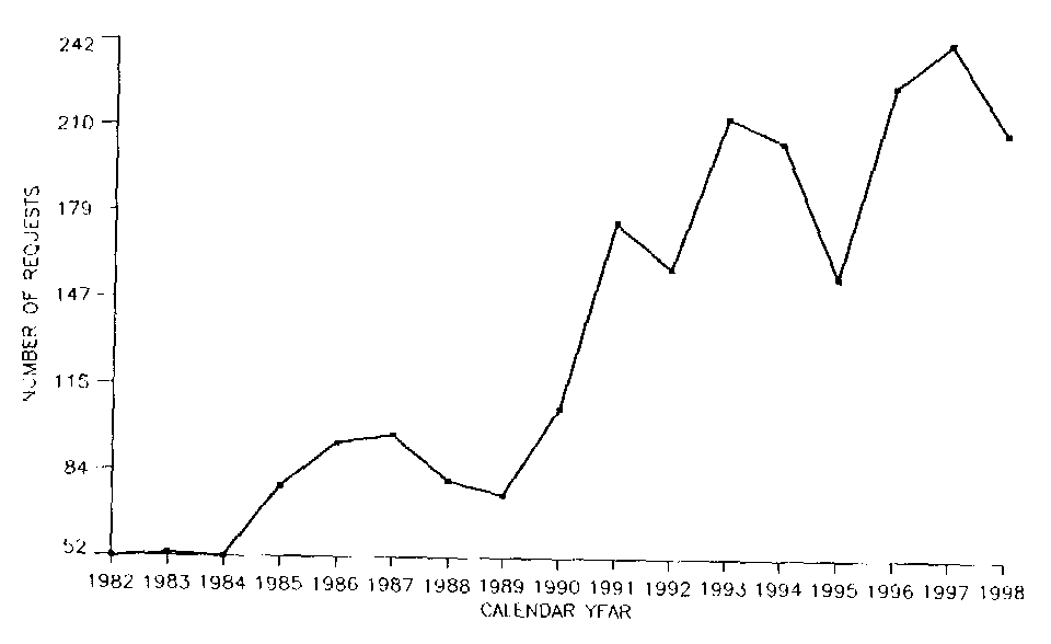
The number of data requests has continued to rise through the period, see the attached graph.
A number of data sets have been contributed to BGI in the period 1995-99, including new airborne data (Switzerland, Greenland mean values) and surface data (Taiwan, Nepal, Indian Ocean Islands, Indonesia a.o.).
BGI has recently computed a new marine gravity field from satellite altimetry from raw 20 Hz measurements, including ice-covered polar areas.
BGI has assisted in various geoid determination activities (Madagascar, Morocco, Jordan, France...)
BGI has participated in regional gravity projects such as the African Gravity Project (AGP), South American Gravity Project (SAGP), and European/Asian projects (SEAGP, WEEGP). BGI has copies of these classified data sets, and has participated in data validation etc.
The BGI various data activities has been reported extensively in the
BGI Bulletin d’Information.
8. PROGRAM OF ACTIVITIES FOR THE NEXT FOUR YEARS
- Continue publication of the Bulletin d'Information.
- Continue data collection, archiving and distribution : emphasis will be on those countries which have not, or seldom, contributed to the BGI data bank. First priority is given to careful data evaluation. Marine data validation, after some experiments were conducted with methods using cross-over difference minimization (over different legs and cruises), is to be based on the gravity field derived from satellite altimetry data.
- Assist IGGC (new International Gravity and Geoid Commission) in setting up the International Absolute Gravity Base Station Network (IAGBN), and assist in the intercomparisons of instruments.
- Establish simple procedures for the collection and archiving of absolute measurements, in the continuation of the work of former Working Group 2 of IGC.
- Link with the IGGC in data preparation in view of geoid computations and evaluations to be performed by the International Geoid Service (IGeS).
- Assist in promoting satellites techniques to improve our global knowledge of the Earth's gravity field : satellite-to-satellite tracking, satellite gradiometry, etc ...
A FEW SELECTED REFERENCES (1995-99)
Adjaout, A., Sarrailh, M, 1997: A new gravity map, a new marine geoid around Japan and the detection of the Kuroshio current. Journal of Geodesy, 71, pp. 725-735.
Balmino, G., Chen, J. Y. and N. Vales, 1996: Main 1o x 1o values of potential functionals over China. BGI Bulletin d’Information no. 79.
Olgiati, A., G. Balmino, M. Sarrailh, C. Green, 1995: Gravity anomalies from satellite altimetry. Bulletin Geodesique 69, pp. 252-260.
Sarrailh, M., G. Balmino, D. Doublet, 1997: The Arctic
and Antarctic oceans gravity field from ERS-1 altimetric data. Proc. "Gravity,
Geoid and Marine Geodesy", Segawa et al. (eds.), IAG Symposium Series 117,
Springer Verlag, pp. 437-444.